![]() This tool allows you to interact with parcels in your map in the same way you interact with the desktop integrated features using the Open Module tool.
This tool allows you to interact with parcels in your map in the same way you interact with the desktop integrated features using the Open Module tool.
This tool requires that the parcel feature class includes the necessary building number and street name information. If you are not certain whether these fields are available, consult your GIS system administrator.
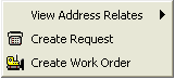
You have three options when using the Address Relationships tool: View Address Relates, Create Request, and Create Work Order. You must right click on a parcel that has an address. If the feature does not have an address you will not be able to use this tool. Right clicking on the desired parcel displays the box shown below: