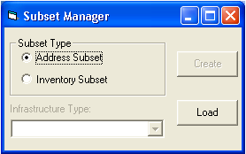
Subsets may be created and loaded in both Lucity™ and Lucity GIS. In Lucity GIS, the Subset Manager allows you to save a group of filtered records from one module as a subset that can be viewed in related modules. For example, if you create a subset in the Television Inspection module of all pipes inspected prior to November 20, 2002, the subset can be viewed in both Television Inspection and Pipe Inventory because the subset contains information pertaining to both modules.
You can also create a subset from a GIS map by selecting a set of features from the map and saving them as a subset. You can then view the subset in Lucity GIS or another related module. In Lucity GIS, subsets are loaded and created with the Subset Manager tool.
While most subsets can only be viewed in related inventory or inspection modules, you can view all subsets in Lucity GIS and the Work Orders module.
Note: Subsets do not automatically update as records are added. If additional records are entered, the subset must be recreated to include the latest data.
 Subsets may be created and loaded in both Lucity™ and Lucity GIS. In Lucity GIS, the Subset Manager allows you to save a group of filtered records from one module as a subset that can be viewed in related modules. For example, if you create a subset in the Television Inspection module of all pipes inspected prior to November 20, 2002, the subset can be viewed in both Television Inspection and Pipe Inventory because the subset contains information pertaining to both modules.