Profile View

  1. To see a profile view of a sewer line, click on the Profile tool .  Use this tool to click on the starting upstream sewer line for your profile.  Once you click on a valid sewer line, you will be prompted for how many segments you want included in your profile.

    Segments in Profile

  2. Enter the total number of segments to include in the profile and click "OK".
  3. The system will ask you whether you want to include marks for manhole surcharge evidence from manhole inspections.  If you enter “Yes”, you will be prompted for a date.

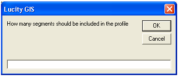
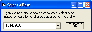
    This date is the max date that will be looked up by the system.  If you use "10/1/1980”, the system will find the last inspection in the system that was performed before 10/1/1980 and use the manhole surcharge evidence measurement from that inspection.

    Surcharge Prompt

    Historical Data

  4. If you are missing critical dates, including rim elevation (from Manhole Inventory), or invert elevations (from Pipe Inventory), the profile will stop at that point.

    Stop Prompt

  5. The final profile is displayed in a new window.

    Profile View

  6. The profile may be resized by stretching the Profile View form.  To make changes to the format of the graph, double click on the graph. This will take you into an edit mode for the graph, where most Excel functions are available.
  7. To save this profile, click the Save button in the upper left hand corner of this screen.  You will be prompted to select a file name in order to save your changes.  
  8. The Print button will print the profile as it is displayed on the screen directly to your default printer. If you want to set more print options, save the profile and edit or print it directly in Microsoft Excel.

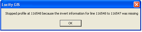
    Notes: This tool is currently only supported for workstations with a licensed copy of Microsoft Excel 8.0 or higher. The fields used to display the invert elevations are found in the center of the “Elevations” tab in Sewer Pipe Inventory:

Record Elev

See Also

GIS General Tools

Open Module Tool

Address Relationships

Customer Search Dialog

Tools Drop-Down Menu

Subset Manager

Add Sidewalk Inspection Defect Location

Show Map Interface

View Work Locations

Work Location Viewer

View Request Locations

Request Location Viewer

Lucity Trace Solver

View TV Observations

Assign Sewer Flow Basin

Assign Storm Flow Basin

View Work Frequency

Linking Lucity Inventory Information to a Feature Layer