The View Work Frequency button allows you to view how often work is happening or has happened in your map. This tool is effective for any work order that has an address, an X and Y Coordinate (Location tab in Work Orders), or assets assigned to the work order in the Assets tab. Some or all of the assets must be in the map.
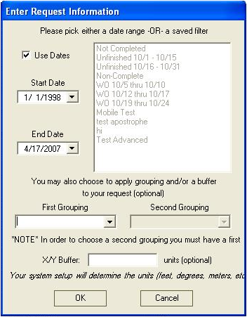
To use this command, click on the View Work Frequency button . You will be prompted with the following dialog:
You'll need to select either a date range or a saved filter:
To select a date range, mark the Use Dates checkbox. Then, select a start and end date from the drop-down calendars.
To use a previously saved filter from the Lucity™ Work Orders module, highlight a filter in the right-hand grid.
Note: The Use Dates checkbox disables the filter grid.
The First and Second Grouping fields are optional. They allow you to select ways to group your results from two drop-down lists. These lists include fields from the Work Orders module such as address and area.
Note: The Second Grouping field can only be used if you have selected a First Grouping.
The X/Y Buffer is also optional. This is used when there are multiple work orders for a single X/Y coordinate. With the buffer in place, the system will increase the work order frequency instead of drawing additional points at the same X/Y coordinate. Your system setup will determine the units you enter. These may be feet, degrees, meters, etc.
Click OK and the system will display the work order frequency that meets your selected criteria. While the system is processing, there will be a progress bar in the lower left-hand corner of the map.
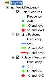
Once the processing is finished, three layers will be added to the table of contents that show the work order frequency for point, line, and polygon features. The symbology for these layers has graduated sizing and color based on frequency. To change the way the frequency is displayed, right click on the layer and go to the symbology tab.
Notes: Start and End Date or the Filter are the only required selection criteria. If you use the start and end date, the system will search for all work orders where the start date is between the start and end date you specified. If you select a saved filter, the system will find all work orders that meet the selection criteria for the saved filter.
The start and end date are inclusive; the system will find all work orders whose start dates are greater than or equal to the start date you specified, and are less than or equal to the end date you specified. Work order end date is not used.
The date used is the Start Date on the first tab of Work Orders. Make sure your users are populating this data or this option will not be effective.