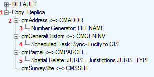
On the left side of the geodatabase configuration is geodatabase connections tree. This tree provides the ability to select, configure, and run tools on different configuration components for different geodatabase connections.
Component Types
The Geodatabase configuration is made up of four different components:

1 |
Geodatabase: |
This is a record for a geodatabase that is configured with Lucity. The tools associated to this component often effect all feature classes configured beneath it.
|
2 |
Feature Class: |
This represents a feature class within the geodatabase that is linked to a Lucity module. Selecting this type of node allows modification of the properties for the feature class and its fields.
|
3 |
Number Generator: |
This is a special function that will automatically populate a feature class field with a incremented number. Select this node to modify the number generator properties.
|
4 |
Scheduled Task |
This is a special function within the geodatabase configuration that schedules and automatic sync of data from Lucity to the geodatabase or from the geodatabase to Lucity. This will start with the words "Scheduled Task" and will then indicate what direction the sync will push data. |
5 |
Spatial Relate: |
This is a special function within the geodatabase configuration that will update a feature class field based on it's proximity to another a feature in another feature class. These kind of relationships are good for keeping track of a parent object and its children. Select this node to modify the spatial relationship properties.
|
As users click on different components within the in the geodatabase connection tree the screen will expand to show different sets of information.
Right-clicking on a configuration component opens up a menu with a list of tools. These tools either effect the structure of the geodatabase or perform batch operations that are available for individual feature classes as well. This section describes most of these tools.
Geodatabase Tool list |
|
Add Feature Class * |
Adds a feature class under the selected geodatabase |
Import Feature Classes From Schema |
Loads pre-configured feature classes into the geodatabase configuration based on either the Lucity or ESRI schema's. |
Delete Multiple Feature Classes * |
Opens a tool that gives a way to quickly delete the pre-configured feature classes an organization is not using. |
Validate Workspace * |
Checks the configuration for errors |
Setup "Update Length/Area" Flag to True |
Turns on all "Update Length/Area" fields |
Domains |
Provides various tools to keep the Lucity Picklists and Geodatabase Domains in sync. |
Modify Feature Class Schema |
Adds/updates several Lucity required fields to feature classes for quick setup. |
Import Feature Class Alias Names |
Updates the Associated Aliases grid for each linked feature class using the Alias name set in ArcCatalog. |
Set "Update Length/Area" Flag to True |
Checks the Always Update Length/Area Field box on all feature class configurations associated to the geodatabase. |
Update Feature Class Services |
Lets users set the Feature Service for multiple feature classes. |
Feature Class Tool List |
|
Add |
Add either a Spatial Relationship, Number Generator, or GIS Task to the selected feature class |
Delete * |
Delete the feature class configuration |
Validate * |
Validate the feature class configuration |
Domains |
Provides various tools to keep the Lucity Picklists and Geodatabase Domains in sync for this feature class. |
Feature Class Schema |
Adds/updates several Lucity required fields to the feature class for quick setup. |
Import Feature Class Alias Names |
Updates the Associated Aliases grid feature class using the alias name set in ArcCatalog. |
* Replica configuration/feature classes have a similar tool.