Icon or Field
Tool or Field Name
Description
![]()
This menu allows you to Clear All, set up Versioning, and select from system options.

This tool allows you to add new feature classes and set them up for synchronization with the desktop inventory modules.

This tool allows you to delete feature classes, auto-numbering fields, spatial relationships, and other items from the setup.
![]()
Adds a new spatial relationship.
![]()
This tool validates your geodatabase configuration.
![]()
This tool allows you to set up auto-numbering for features.
![]()
Help
This button opens the desktop help file to the Custom Geodatabase Synchronizer setup topic.
![]()
Contains the Lucity module name.
![]()
This field allows you to indicate or change the names of the feature classes in the setup.
![]()
Contains the feature class common link fields.
![]()
Contains the Lucity table name.
![]()
Contains the Feature Class Lucity AutoNumber Link.
![]()
Indicates whether records in the geodatabase have been synchronized with Lucity.
![]()
Used to disable a feature class so that it is not used with Lucity GIS. This helps improve performance.
![]()
Indicates whether the Lucity GIS extension should update the feature class length field when spatial edits are made.
![]()
![]()
Indicates which fields in your feature class store the Last Modified By, Last Modified Date, and Last Synchronization Date.
![]()
Used to track the layer index for the Web Map.
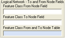
Contains the To/From Node fields for feature classes that require a logical network to be built.
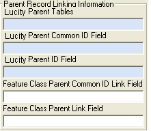
Identifies relationships with other modules.