This is way the form will look like when populated with the standard Lucity geodatabase settings.
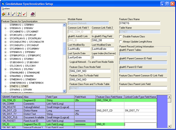
This Geodatabase Synchronization Setup tool can be used for the following:
This is way the form will look like when populated with the standard Lucity geodatabase settings.
Notes: See Spatial Relationships for information on how to set up the system to automatically update these fields. If the spatial relationships function is not used, the user will be responsible for keeping these values current.
The Sewer Pump Station Inventory, Storm Pump Station Inventory, and Detention Basin Inventory modules may be maintained automatically if the option in Sewer Editing options is checked. See Sewer Editing Options or Storm Editing Options for more information.
For these three feature classes, you must maintain two additional fields: One character field that stores the structure number, and one ID field that stores the structure ID. These fields should be mapped to the Feature Class Parent Common ID Link Field and Feature Class Parent Link field, respectively. The field entered for the Feature Class Parent Link field must be mapped to the associated field in the grid as well. For sewer pump stations this is the SN_MHID field; for storm pump stations this is the PN_SN_ID; for storm detention basins this is DN_SN_ID.