Layer Index

The Layer Index corresponds to the index of the layer in the ArcGIS Server (AGS) map resource REST service that is defined in UI Admin > System Settings > Geodata Map Service.

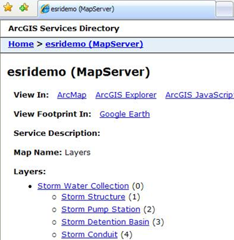
If you paste the URL (i.e. http://[Windows User]/ArcGIS/rest/services/esridemo/MapServer) from the Geodata map service into a web browser you'll see something like the example below. Note that the number in parentheses represents the layer index.

layer

See Also

Custom Geodatabase Fields and Tools

System

Adding New Feature Classes

Delete Tool

Adding Spatial Relationships

Validating Custom Geodatabase Setup

Setting up Auto-Numbering for Features

Module Name

Feature Class Name

Feature Class Common Link Fields

Table Name

Feature Class Lucity AutoNumber Link

In Lucity Flag Field

Disable Feature Class

Always Update Length/Area

Last Mod By/Last Mod Date/Last Synch Date

Logical Network - To and From Nodes

Parent Record Linking Information