Adding Spatial Relationships

  1. To add a spatial relationship, select the feature to which you wish to add the relationship from the tree on the left-hand side of the Geodatabase Synchronization Setup form.
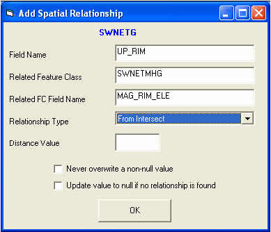
  2. Click the Add Spatial Relationship tool located at the top of the form.  The Add Spatial Relationship dialog will be displayed with the selected feature class at the top of the screen.

    Spatial Rel

  3. Populate the Field Name on the Add Spatial Relationship form. This is required.  This is the field name in the selected feature class that you would like to have automatically updated.
  4. Populate the Related Feature Class. This is required. This is the feature class name, without owner or database name qualifiers, that will relate to the selected feature class.  This feature class does not have to be set up to synchronize with the desktop and does not need to be in the same format.  It can be a shapefile, personal geodatabase feature class, or enterprise geodatabase feature class.  Non ArcSDE feature classes will be significantly slower than ArcSDE feature classes.
  5. Populate the FC Field Name. This is required. This is the field name in the Related Feature Class that contains the value you would like propagated to the field defined in the "Field Name" field.
  6. Populate the Relationship Type. This is required. This is a drop down pick list defining the relationship type.  The table below lists the available relationship types:

    From Intersect

    Finds any features in the Related Feature Class that intersect the from point of the feature in the selected feature class. This relationship only works for polyline, edge, or complex edge features.

    To Intersect

    Finds any features in the Related Feature Class that intersect the to point of the feature in the selected feature class. This relationship only works for polyline, edge, or complex edge features.

    Is Contained By

    Finds any features in the selected feature class that are contained by features in the related feature class.  The related feature class must be a polygon feature class.

    Intersects

    Finds the first feature in the related feature class that intersects the feature in the selected feature class.

    US Intersect Distance

    Finds the first feature in the related feature class that intersects the feature in the selected feature class, then calculates the distance along the line that the intersection occurs, from the From point.  The selected feature class must be a polyline, edge, or complex edge feature class.

    DS Intersect Distance

    Finds the first feature in the related feature class that intersects the feature in the selected feature class, then calculates the distance along the line that the intersection occurs, from the To point.  The selected feature class must be a polyline, edge, or complex edge feature class.

    Midpoint Intersect

    Finds any feature in the related feature class that intersects the midpoint of the feature in the selected feature class.  This relationship is designed for polyline, edge, or complex edge features as the selected feature class, and a polygon feature class for the related feature class.

    Force Related Feature to Self-Update

    This relationship finds any features that intersect the feature in the selected feature class and adds them to the edit cache. This allows them to be synched to the desktop even if the records have not changed.  This is used primarily for the street segment feature class (as the selected feature class) and the street intersection feature class as the related feature class. This forces the intersections to automatically recalculate the intersection configurations for the intersection configuration diagram in the Intersection module when street segments are changed.

    Is Within Distance Of

    Finds all features in the related feature class that are within a specified distance of the feature in the selected feature class.

  7. Populate the Distance Value. This is required only if relationship type = "Is Within Distance Of".  This field is used to specify a distance if the "Is Within Distance Of" option is chosen from the relationship type.
  8. Never Overwrite a Non-Null Value. This is optional. Check this box to ensure that once data has been populated into the "Field Name" field in the selected feature class, it never gets overwritten again.
  9. Update Value to Null if No Relationship is Found. This is optional. Check this box to allow the "Field Name" field to be sent to null if no relationship is found.
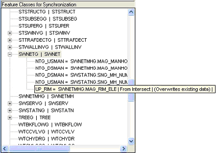
  10. Click OK. The spatial relationship will be added to the Geodatabase Synchronization Setup and can be viewed by selecting the feature class in the tree and clicking the "+" next to the feature class.  A  list of the spatial relationships will be displayed.

    spatial relationship

See Also

Custom Geodatabase Fields and Tools

System

Adding New Feature Classes

Delete Tool

Validating Custom Geodatabase Setup

Setting up Auto-Numbering for Features

Module Name

Feature Class Name

Feature Class Common Link Fields

Table Name

Feature Class Lucity AutoNumber Link

In Lucity Flag Field

Disable Feature Class

Always Update Length/Area

Last Mod By/Last Mod Date/Last Synch Date

Layer Index

Logical Network - To and From Nodes

Parent Record Linking Information