![]()
The Data table allows users to see information about and interact with features that are currently selected or work order and request locations that are plotted. This table is opened automatically when either the Selection tool or Show Work Locations tools are used.
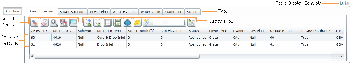
Table Display Controls
To the top right of the table are two buttons that control the tables appearance.
|
Click this button to expand the table and show more records |
|
Click this button to close the table. This does not clear the current selection. |
|
|
Tabs
At the top of the grid there is a row of tabs. Each tab corresponds to a feature classes that has features included in the current selection. Click on a tab to switch to a table showing the selected features for that feature class.
User Point Graphics created using the Create Work Point tool will show up on a tab called UserPointGraphics.
|
Selected Records
Features that appear in the table are currently Selected. They are displayed in the map using the Main Selection Color.
Note: The Main and Secondary Selection Colors are changed using the Display Preferences tool.
|
Selection Controls
The Selection controls allow users to control the current feature selection.
|
|
Clear Selection |
Un-selects any features that are currently highlighted in the table. This removes them from the Data Table |
|
|
Clear Highlight |
Un-highlights any records that are currently highlighted in the table. They remain selected. |
|
|
Zoom and Flash Highlight |
Zooms to the features highlighted in the table. |
|
|
Switch Highlight |
Switches which records are highlighted in the table. Any records that are currently highlighted will not be, any records that weren't highlighted will be. |
|
|
Highlight All In Selection |
Highlights all records in the current table. |
|
|
|
|
Lucity Tools
These tools allow users to perform Lucity operations against features in the map.
Note: To use these tools users must high light one or more features in the table.
|
|
Attaches the currently selected assets, or currently highlighted assets to an existing Subset. |
|
|
|
Creates a subset using the currently selected assets, or currently highlighted assets. |
|
|
|
Shows all Lucity modules and records related to a highlighted asset. Users can then jump to a related module. |
|
|
|
Allows users to view documents attached to a highlighted feature, and attach new documents. |
|
|
|
Creates a request for a highlighted asset. |
|
|
|
Creates a work order for all highlighted assets. |
|
|
|
Attaches highlighted assets to a existing Work Order. |
|
|
|
Create PM/Template |
Creates a standard PM/Template for all highlighted assets. |