![]()
Log
Click on this tool to bring up a selection of troubleshooting tools. Select a tool from the list and click OK to open it.
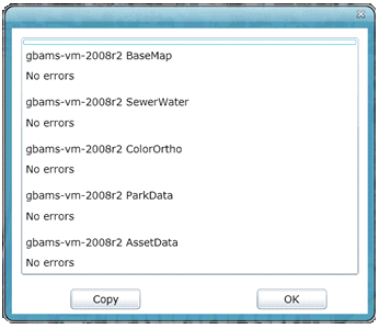
Local Log - Click on this button to bring up a log for the web map. 
![]()
View Layer Details - Right-click for a dropdown menu with the option to view layer details. This will show the map services displayed in this map, and which layers are linked back to Lucity.
![]()
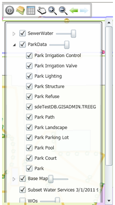
This allows users to: turn feature classes off and on, control selectability, and control layer transparency. ![]()
![]()
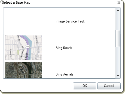
Base Map
Provides a list of base maps to choose from. Only one base map can be viewed at a time. ![]()
![]()
The data table shows a table view of all records that have been selected. It has several tools to help when selecting records, and special tools to relate asset records back to Lucity.
![]()
Display Preferences
This allows users to change the following options.
Main Selection Color - the color of selected features.
Secondary Selection Color - The color features that have been selected from a selection.
Automatically revert to pan after select - After using the Select tool the map automatically switches back to the Pan tool.
![]()
Pan
This allows users to pan around the map. If no other tool is selected this one is selected by default.
![]()
Zoom In
This allows users to zoom in. Select the tool then click on the map to zoom in. Users can also click in the map and drag the cursor to form a box. Click again to finish the box and zoom.
![]()
Zoom Out
This allows users to zoom out. Select the tool then click on the map to zoom out. Users can also click in the map and drag the cursor to form a box. Click again to finish the box and zoom.
![]()
Return to the Previous Extent
Cycles backwards through previous map extents
![]()
Return to Next Map View
Cycles forward through previous map extents
![]()
A set of tools that allow users to make measurements of Lines, Polygons, and Circles.
![]()
Allows users to add markups to the map. This can be used to provide information to somebody at another location with information, or to save information for later.