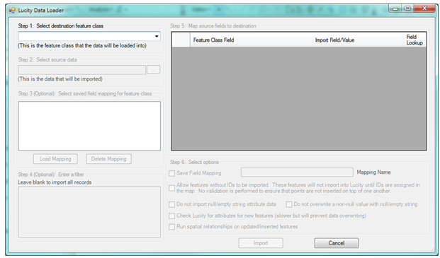
![]() The Lucity Data Loader allows users to perform a mass data import and/or update to the geodatabase. This tool will import features into both a Lucity linked feature class and the corresponding Lucity module at the same time. It can also be used on existing features to update spatial and attribute data. The Lucity GIS Data Loader can perform the following functions:
The Lucity Data Loader allows users to perform a mass data import and/or update to the geodatabase. This tool will import features into both a Lucity linked feature class and the corresponding Lucity module at the same time. It can also be used on existing features to update spatial and attribute data. The Lucity GIS Data Loader can perform the following functions:
Common Uses

Step 1: Select Destination feature class |
This allows users to select a feature to load data into. The list provided contains feature classes that are linked to Lucity. |
|
Step 2: Select source data |
This is to select the shapefile or feature class the data will be imported from. |
|
Step 3: (optional) Select saved field mappings for feature class |
If this is a regular process users can setup and save a field mapping for a feature class. If they have one previously saved they can select it here to load the saved mapping. |
|
Step 4: (optional) Enter a filter |
This box allows users to enter an SQL select statement to filter for a set of records during the import. |
|
Step 5: Map source fields to destination |
This grid displays the fields in the feature class from Step 1, and allows them to match up fields from the Import file in Step 2. |
|
Step 6: Select Options |
There are several options that allow the user to control how the import functions. |
|
|
Save Field Mapping |
Check this box to save the field mapping. The next time the Lucity Data Loader tool is used on that feature class the saved mapping will be available in Step 3. |
|
Allow features without IDs to be imported |
This special option for importing data allows features to be imported without a Facility ID. This is available so that data can be brought into the geodatabase without an ID and later the IDs can be entered directly into the geodatabase itself. When choosing this option it is critical that the data is only imported once, otherwise the data will continually append itself to the geodatabase. |
|
Do not import null/empty string attribute data |
If a field in the source record (from Step 2) contains a null/empty string value the value will not be sent to the destination record in the feature class or Lucity database. This is especially important when using the Lucity Data Loader to update existing features. |
|
Do not overwrite a non-null value with null/empty string |
If using the Lucity Data Loader to update an existing feature this will prevent existing information from being overwritten with null/empty string data. |