|
|
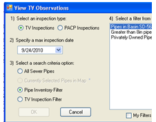
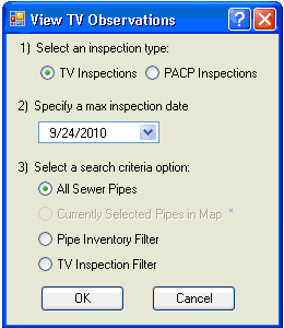
Select an inspection type |
Select which module the inspection observations are stored in. |
Select a max inspection date |
This tool displays the observations for the most recent inspections for each pipe based on the date. Select a max date to limit the date range of the inspection shown. For example if a user selects 9/24/2010 the tool will only display observations for inspections that occurred before 9/24/2010. |
Select a search criteria option |
This allows users to limit the number of pipes the tool is run against. They can run the tool against all sewer pipes, those currently selected in the map, or filters saved in lucity in the Pipe Inventory, and TV Inspection modules. This is useful for only viewing observations for pipes that are in a certain area, or are made of a certain type of material. |