The following feature classes are available in the sewer feature dataset:
Note: Refer to Editing Requirements for a description of the format of these requirements.
Feature Class Type
Feature Class Name
Required Fields (Alias)
SEWER STRUCTURES
SWNETMHG
MAG_MANHOLE [Structure]
SEWER PIPES
SWNETG
Each pipe that you want in the Lucity™ database must have a structure on each end of the line. To determine whether or not you want a pipe stored in the Lucity database asK yourself these questions:
Do I want to attach this sewer pipe to work orders?
Do I want to store inspections for this line?
Do I want to store some of the extended inventory available in the Sewer Pipe Inventory module, but not available in the geodatabase for this line? Look in the Sewer Pipe Inventory module to see what data may be stored.
If you answered yes to any of these questions, you will want to have your pipe stored in the Lucity database:
For most sewer pipes this is pretty straightforward because there is usually a manhole of some sort on each end of the pipe. The pipe must be snapped to these structures. Also, these structures must meet their minimum requirements (unique value in Structure, see above).
For pipe stubs, you will need to insert a structure at the endpoint of the stub. You can assign this pipe cap a structure type of 'N/A' or any other custom structure types you want to add. For information on adding structure types, see Adding Code/Types or Domain values. Again, these pipe cap structures and any other structure must meet the minimum requirements (unique value in Structure, see above).
If you answered no to the questions stated above, you can draw your line and assign whatever attributes to it you want. There are no restrictions. This line will exist in your geodatabase/map but will not be accessible for attaching work orders or inspections. You may consider doing this for pipe stubs if you are not going to be maintaining them before they are completed.
If you are mapping parallel pipes, or any pipes that start and end at the same two structures, you will need to change the "i" field on one of the pipes. This "i" field is the Index for the pipes. By default, i = 1. If you have four pipes in parallel, you will have i = 1, i = 2, i = 3, i = 4. In Lucity, these i values are used to generate a secondary upstream structure number. To view or change the format of this secondary "dummy" structure, see the Sewer Editing Options under Editing Options > Sewer Editing options on the Lucity GIS Editing Tools toolbar.
Note: Sewer lines must always be drawn in the correct direction of flow.
Feature Class Type
Feature Class Name
Required Fields (Alias)
SEWER PUMP STATIONS
SWSTATNG
SN_NODE_NO [Pump Station ID]
Every pump station must be tied to a sewer structure in your system. This maintains your sewer network. You can do this in two ways:
Insert a sewer structure at the same point as your pump station. Make sure this structure meets its minimum requirements (unique value in Structure).
Set up your Sewer Editing options to automatically insert the structure number for you. With this option, the linked structure number is assigned after you save edits.
If you are drawing sewer lines to and from the pump station, there are two options:
Add these sewer lines after you save edits on the pump stations you added.
If you already have drawn your sewer lines, save edits on the pump stations, select the attached sewer lines using the Update Spatial Relationships tool on the Lucity GIS Editing Toolbar. This tool will update the selected sewer lines and make sure that each line has an upstream and downstream structure assigned to it. This Update Spatial Relationships tool only works in while you are editing your geodatabase.
Feature Class Type
Feature Class Name
Required Fields (Alias)
SEWER PUMPS
SWPUMPSG
PMG_STN_NO []
PMG_PUMP_NO []
Each pump must be assigned to a pump station. This is done by putting the pump station number in the PMG_STN_NO field.
Feature Class Type
Feature Class Name
Required Fields (Alias)
SEWER SERVICES
SWSERVG
SVG_STRC_ID [Structure]
SVG_CON_NO [Lateral No.]
Address information is not required for this feature class. The Structure field continues to be a required field and must be unique.
Lateral number will always be 1, unless there is more than one service lateral at a single address.
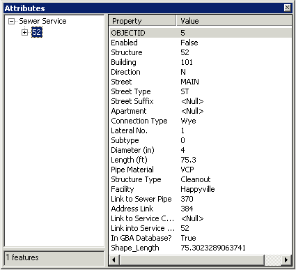
This feature class populates the Sewer Service Lateral Inventory module and the Customers database (if you elect to do this). When you are filling out the address information, make sure that all fields are filled in for the address if there is an appropriate value. For instance, for 101 N MAIN ST, this is what your attribute editor should look like:
When you save edits, Lucity GIS will check to see if that address exists in your Customer module. If it does exist, it will automatically link the service lateral to this address. If it does not exist, and you have the Update Address option checked in the Sewer options, the address will be inserted into the Customers module.
Note: Service Laterals should always be drawn in direction of flow, but are not required to be snapped to a sewer pipe; however, they should be if possible. The service lateral should never break a sewer line.
Feature Class Type
Feature Class Name
Required Fields (Alias)
SEWER SERVICE STRUCTURES
SWSERVSG
Service structures include assets like cleanouts that are attached to a service lateral. Service structures are not stored in a separate module in Lucity; the attributes for these structures are stored with the service lateral information in the Service Lateral Inventory module. The purpose of this feature class is to allow you to map the approximate or exact locations of your service structures. There are no required fields for this feature class because it is not synchronized with