Lucity GIS contains an editor extension that tracks edits made to the geodatabase linked to Lucity. The editor ensures that these edits are synchronized with the Lucity databases.
The functions of the tools found on the Lucity GIS Edit toolbar are described in the table below.
Tool
|
Name
|
Function
|

|
Process Log
|
Displays error messages and other information about Lucity GIS tool activities.
|

|
Add Lucity Layers
|
Enables users to quickly add Lucity linked feature classes into the map.
|

|
Lucity GIS Edit Session Status
|
Indicates the current status of the Lucity Edit session:
- Red - Session not enabled
- Yellow - Session is initializing.
- Green - Session is enabled.
|

|
Lucity Data Loader
|
Allows users to perform a mass data import and/or update to the geodatabase and Lucity.
|

|
Update Spatial Relationships
|
Updates any spatial relationships assigned for the selected features.
Spatial relationships, which are set up in the geodatabase configuration, are used to update an attribute of a feature based on that of a feature with a similar or related location.
|

|
Force Syncronization
|
Runs the synchronization process on demand, against the selected features. Primarily used to push changes made outside of a Lucity Edit session into Lucity.
|

|
Delete
|
Removes features from the map and from Lucity at the same time.
|

|
Clear Lucity Edit Cache
|
Empties the Lucity Edit cache for the current user, which stops recent ArcMap edits from being pushed to Lucity.
|

|
Disable Lucity Editor
|
Disables all of the Lucity Edit tools.
|

|
Settings
|
Displays map settings that streamline the process of logging into Lucity while in ArcMap. Also provides some user settings to control how the Lucity GIS tools work.
|

|
Lucity Renumber
|
Provides a special tool to renumber any Lucity feature in the map that is not a Sewer, Storm, or Water asset.
|

|
Sewer Tools
|
Provides special tools for specific Sewer edits that must be performed in Lucity and in ArcMap at the same time: Sewer Renumber, Sewer Merge, Sewer Split, and Sewer Reverse Flow.
|

|
Storm Tools
|
Provides special tools for specific Storm edits that must be performed in Lucity and in ArcMap at the same time: Storm Renumber, Storm Merge, Storm Split, and Storm Reverse Flow.
|

|
Street Tools
|
Provides special tools for specific Street edits that must be performed in Lucity and in ArcMap at the same time: Renumber Street Feature, Merge Segments, Split Segments, Split Subsegments, and Merge Subsegments. There are also tools to manage supersegments: Define Supersegments, Dissolve Supersegments and Generate Supersegment Features.
|

|
Water Tools
|
Provides special tools for specific Water edits that must be performed in Lucity and in ArcMap at the same time: Water Renumber, Water Merge, and Water Split.
|

|
Alias Import
|
Associates the aliases currently defined for all Lucity feature classes in the map with the feature classes in the Lucity geodatabase configuration.
|

|
Direct Spatial Relationships
|
Updates Lucity fields on demand, based on the attribute of a feature with a similar or related location. Eliminates the need to create a field in the geodatabase to store a value from another feature class that will then be sent to Lucity.
|

|
Help
|
Opens Lucity GIS Web Help to the section on the editing tools.
|
- On the ArcMap Editor toolbar, click Editor > Start Editing. If the toolbar is not available, go to View > Toolbars and select Editor to load it.
Note: Make sure the Lucity GIS Editing Tools 2016r2 toolbar is loaded.
- The ArcMap edit session starts, and Lucity GIS checks whether a user is logged in yet. If no users are logged into Lucity GIS in this ArcMap session, a login prompt appears.
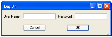
(This is the same login/password as your standard Lucity login.)
- The system takes a few moments to retrieve the necessary data and settings. Then, it notifies the user that, upon completion of the edits, it will update Lucity Desktop. This prompt appears once during the ArcGIS session.
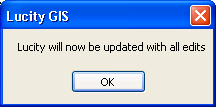
Warning: If users start editing a Lucity geodatabase and do not receive this message, something is wrong. They should stop editing, close the project, reopen it, and try to start editing again. If they still do not receive this message, contact a Lucity Support representative. Another indicator that there is something wrong with the edit session is the color of the Lucity Edit Session Status. If this tool is yellow or red it is having trouble recognzing that your data is linked to Lucity.
Once the edit session starts, the Lucity GIS Editing toolbar is enabled and the Edit Session Status changes from yellow to green.

Once edits have been made, they must be saved in ArcMap in order for Lucity to sync them.
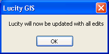
- After making edits, go to the ESRI Editor toolbar and select Editor > Stop Editing or Save Edits. Select the option to Save Edits, and a prompt appears to notify the user that Lucity will be updated.
Note: If users do not save edits, Lucity will not sync them.
- The system pauses for a few moments as it determines what needs to be updated. A progress bar appears in the lower-right-hand corner of ArcMap, and the Edit Session Status shifts to yellow. Do not close ArcMap during processing; if you do, the changes will not be applied to Lucity Desktop.
- The progress bar runs twice to 100%.
- The first time, it reorders features to ensure they are updated in Lucity Desktop in the correct order and retrieves information required for the synchronization. Depending upon the number of fields that must be updated and the computer's memory, a pause may occur at 100%.
- After the second progress bar reaches 100%, the progress bar will disappear, indicating that the Lucity updates are complete. The Edit Session Status returns to green.
Note: When a user deletes a feature from the map using the Delete key, the system does not delete the feature from Lucity; instead, it changes its Status to "Not in Map." To tell whether or not a feature is in the map, open the Inventory module for that feature and locate the item. If the Show in Map button is enabled, the feature is in the geodatabase. If the Show in Map button is disabled, the feature is not in the geodatabase.
There is a special Delete tool on the Lucity Editor Toolbar that enables users to delete features both in the map and in Lucity Desktop simultaneously.
In some cases you may want to work with data in ArcMap without the Lucity Editor. For example you might be doing bulk edits on Lucity data or you are editing a Lucity linked feature class but are not editing fields linked to Lucity fields. In either of these scenarios disabling the Lucity Editor will speed up your edit session. If you make edits during a disabled session that need to be pushed to Lucity you can open a new session and sync them.
The Editor extension can be disabled using one of the two methods:
Short Term
Long Term
 How to start the Lucity GIS Editor