 To improve general editing and maintain relationships between features, Lucity GIS has a Spatial Relationships function that automatically updates GIS features based on their relative location to items in another feature class.
To improve general editing and maintain relationships between features, Lucity GIS has a Spatial Relationships function that automatically updates GIS features based on their relative location to items in another feature class.
For example, most agencies have established a relationship between Park Playgrounds and Parks so that the playgrounds are automatically assigned the correct park ID number. If an agency does not set up this spatial relationship, users must maintain these fields manually.
Note: For more information on setting up spatial relationships, see the Spatial Relationships help guide.
Spatial relationships run automatically whenever a new feature is created, an existing feature's Facility ID is modified, or a feature's Shape/Location is changed. However, in certain circumstances, spatial relationships are not updated automatically. In such cases, the Update Spatial Relationship tool is used to update the records.
Common Uses
The Update Spatial Relationships tool is valuable when:
Note: If, after using this tool, the feature attributes are not modified as expected, check to make sure features are snapped using the ArcMap tools. If the problem persists, make sure the spatial relationship is properly defined in the geodatabase configuration.
How To Update Spatial Relationships
on the Lucity GIS Edit toolbar. A message similar to the one below appears in order to verify the number of features selected . 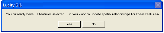
Do not use the Update Spatial Relationships tool to force features to synchronize to Lucity Desktop; use the Force Synchronization tool instead. The Update Spatial Relationships tool will not synchronize features that are not the target of a spatial relationship.
Note: It is not necessary to use this tool on features that are currently being edited or added; the Lucity Desktop automatically updates spatial relationships any time any change is made to a feature.