Direct Spatial Updates Features
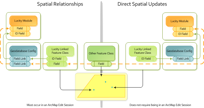
The Direct Spatial Updates tool allows users to directly update a Lucity record from a feature that shares a location with the lucity linked feature without updating the lucity linked feature itself.
Direct Spatial Updates Features
Direct Spatial Relationships Tool
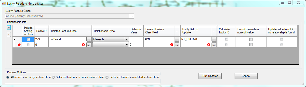
Tool Elements
Lucity Feature Class
Enables the user to select a Lucity feature class from the map to indicate which Lucity module will be updated by the Direct Spatial Updates tool.
Relationship Info
Lists the spatial relationships for the selected Lucity feature class/module.
+ |
Adds a new Relationship to the grid. |
- |
Removes the selected Relationship from the grid. |
Include Setting in Run |
Directs the system to include this relationship when the Run Updates button is clicked. |
RelateID |
Represents the system-defined, unique ID for the relationship. (Completed automatically.) |
Related Feature Class |
Indicates the feature class in the map that that will serve as the source of the update values. |
Relationship Type |
Specifies the rule upon which the update is based.
|
Distance Value |
Specifies the distance around the feature that the tool will search for when the Is Within a Distance of option is enabled. The unit of measure is based on the map units used in the .mxd map document. |
Related Feature Class Field |
Identifies the field in the Related Feature Class that will be used to update a field in Lucity. |
Lucity Field to Update |
Identifies the the field in the Lucity module that will be updated. Note: This field cannot be linked to a feature class; therefore, such fields are excluded from the drop-down. This restriction prevents data from getting out of sync. |
Calculate Lucity ID |
When enabled and the field being updated is the code or type portion of a pick-list field, this option directs the system to look up and complete the other half of the pick-list field (code or type). This feature also applies when the field being updated is a field that stores a Lucity record number for a parent record. When this type of field is updated, the system looks up the parent's Common ID. |
Do not overwrite a non-null value |
Tells the system not to overwrite any pre-existing data in the Lucity Field to Update. |
Update value to null if no relationship is found |
Directs the system to update the Lucity Field to Update as NULL when it cannot identify a relationship between the Lucity feature and a feature in the related feature class. |
Process Options
Control which records in the feature class are updated.
All Records in Lucity feature class |
Runs the tool against all records in the Lucity Feature Class. |
Selected features in Lucity feature class |
Runs the tool against all selected records from the Lucity Feature Class. |
Selected features in related feature class |
Runs the tool against the selected records from the Related Feature Class, identifies the Lucity records that meet the Relationship Type, then updates only those Lucity records. |
Run Updates |
Performs all updates that have the Include Setting in Run box checked. Saves all updates that were created. |
Cancel |
Cancels use of the tool. |