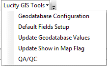
ArcCatalog Tools
To access the Lucity GIS ArcCatalog tools, open ArcCatalog and click on  .
.
These tools will allow you to:
|
|
- Configures the geodatabase feature classes with Lucity modules
|
- Configures which fields are used in the data grids that popup when creating a work order/ req/inspection in ArcMap
|
- Pulls data from Lucity to update linked geodatabase fields
|
- Updates Lucity to make sure it recognizes which features can be shown in map
|
- Preforms QA/QC checks against a feature class
|
How To
Run an ArcCatalog tool
- In ArcCatalog, Click on
 and select the desired tool.
 - The logon screen will appear. Put in a Lucity username and password
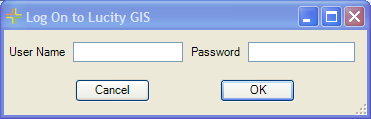
Note: This will not appear if Lucity Windows Authentication is configured for the current user.
- If the username and password are valid the client selection screen will appear. Select a Client from the List
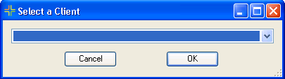
Note: This screen will not appear if there is only one client for an organization.
- Once this has been done in a session of ArcCatalog, it does not have to be done again until ArcCatalog is closed and re-opened.
Note: If the Lucity GIS tools toolbar isn't visible, right-click in toolbars and select Lucity GIS 7.40 from the menu.