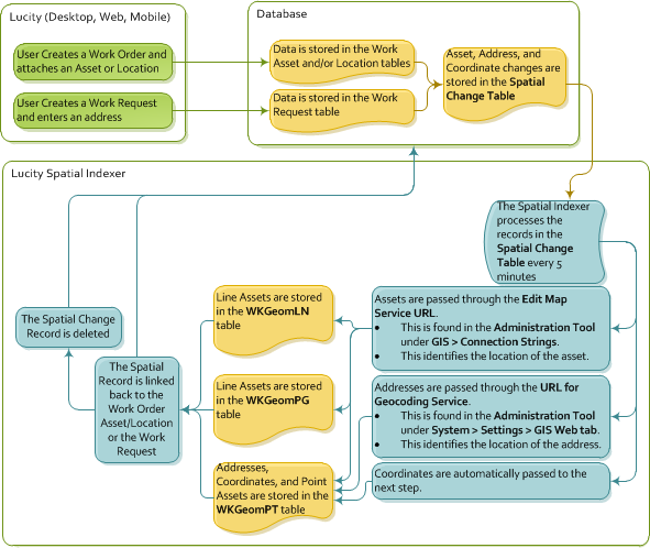
The Lucity Spatial Indexer process is designed to review work order and work request addresses, coordinates, and assets and store the related spatial information in a special table. This data can then be viewed using special Lucity GIS tools.
Configuration
Note: All of the feature classes that are linked to lucity should be contained in this service or an Alternate Feature Service that is directly linked to the feature classes in the Geodatabase configuration.
Restrictions
Process

Records that Fail to Process
Sometimes there are records that fail to process. When a spatial change record cannot be processed it is kept in the Spatial Change table (GBAWork.WKSPATIALCHANGE) and marked with an error code. These records are kept in the Spatial Change table for thirty days after they were initially processed. After 30 days they are deleted.
Error Codes
The error codes are found in the SPCH_SU_ERROR.
MissingData |
This usually means that there is an issue with the data in WKSPATIALCHANGE like the moduleID is invalid, ParentRecID is invalid, invalid x/y data, etc. |
ServiceIssue |
This occurs if there isn't a map service associated with the feature class OR if the feature class related to this asset type is not in the service. |
NoGeometry |
Returned if a geometry was found but it was empty, if the indexer was unable to geocode an address, or if there was an issue with the REST call to retrieve the geometry. |
NoLucityRecord |
Returned if the associated record no longer exists in Lucity. |
How To Process Records that have failed