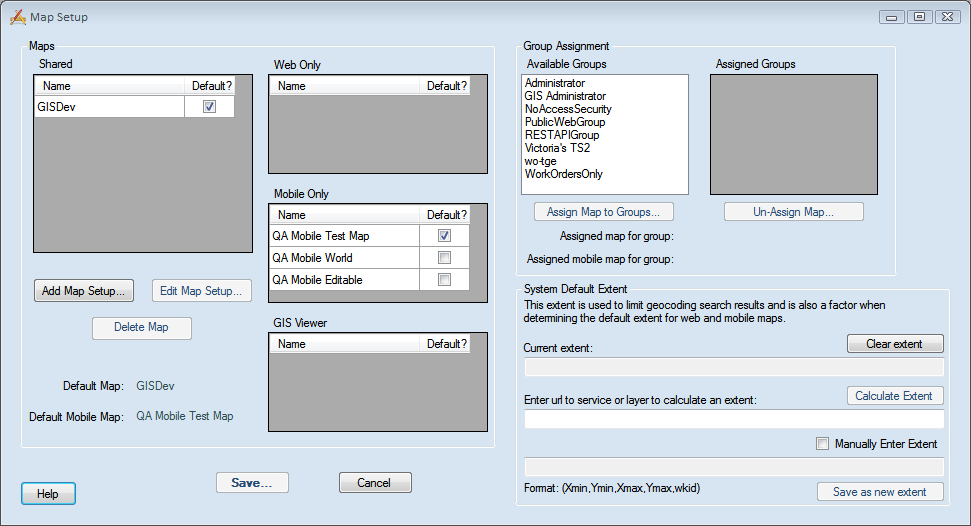
After map services are configured with Lucity, an agency must create a map in the Lucity Administration Tool by layering map services.
The Map Setup tool enables administrators to define maps and assign them to different groups of users. The process is used to create maps for the Lucity Web Map, Lucity GIS Viewer, and for Lucity Mobile - Map Mode.

Maps |
This section allows you to manage your different maps. |
||
|
Shared |
This is a list of maps that are available for both the Web and Mobile applications. |
|
|
Web Only |
This is a list of maps that are only available for the Web application. |
|
|
Mobile Only |
This is a list of maps that are only available for the Mobile applications. |
|
|
GIS Viewer |
This is a list of maps that are available for the GIS Viewer application. |
|
|
Add Map Setup |
Adds a new Map. |
|
|
Edit Map Setup |
Edits the Map currently selected in one of the grids. |
|
|
Delete Map |
Delete the map currently selected in one of the grids. |
|
|
Default Map |
Indicates the map marked as the Default Web Map. This is the map loaded for all web map users unless they have are assigned a different map. |
|
|
Default Mobile Map |
Indicates the map marked as the Default Mobile Map. This is the map loaded for all Mobile users unless they have are assigned a different map. |
|
Group Assignment |
This section allows you to manage which groups are assigned to the map selected on the left. |
||
|
Available Groups |
The list of groups that could be assigned a default map. This list is populated with the security groups that assigned as a Default Rules group in the Lucity Security Program. |
|
|
Assign Map to Groups |
Assign the selected map as the default map for the group selected in the Available Groups grid. |
|
|
Assigned Groups |
A list of groups assigned to the selected map. |
|
|
Un-Assign Map |
Un-associates the selected map and the group selected in the Assigned Groups grid. |
|
|
Assigned Map for Group |
Indicates the map currently associated to group selected in the Available Groups grid. |
|
|
Assigned Mobile Map for Group |
Indicates the mobile map currently associated to the group selected in the Available Groups grid. |
|
System Default Extent |
This section lets admins limit the area that a geocoder searches when locating addresses in the map. This speeds up searching when using a large area goecoding service. Note: To use this you must be on ArcGIS 10.2 or higher have the System > Settings > GIS Web tab > Flag indicating that geocoding services are still ArcGIS 10.1 set to False. |
||
|
Current Extent |
Displays the extent that is currently selected. Is modified using some of the fields below. |
|
|
Clear Extent |
Clears out the Current Extent field. |
|
|
Enter url to service or layer to calculate an extent |
This is used to calculate the Current Extent field. Enter the URL for a map server or layer within a map service into this field. The program will use the URL to copy the service/layers Full Extent/Extent and set the Current Extent field. |
|
|
Calculate Extent |
Click this to calculate the Current Extent from the Enter url to service or layer to calculate an extent field. |
|
|
Manually Enter Extent |
Mark this to unlock the Manual Entry field |
|
|
Manual Entry Field |
Mark the checkbox to use this field. Enter the extent you want using the following Format. Xmin, Ymin, Xmax, Ymax, wkid |
|
|
Save as new extent |
Click this to save the manually entered extent as the Current Extent. |
|
Help |
Launches the Help guide. |
||
Save... |
Saves any changes made to the map setup. |
||
Cancel |
cancels any changes made to this screen. |
||
Considerations