After map services are configured with Lucity, an agency must create a map in the Lucity Administration Tool by layering map services.
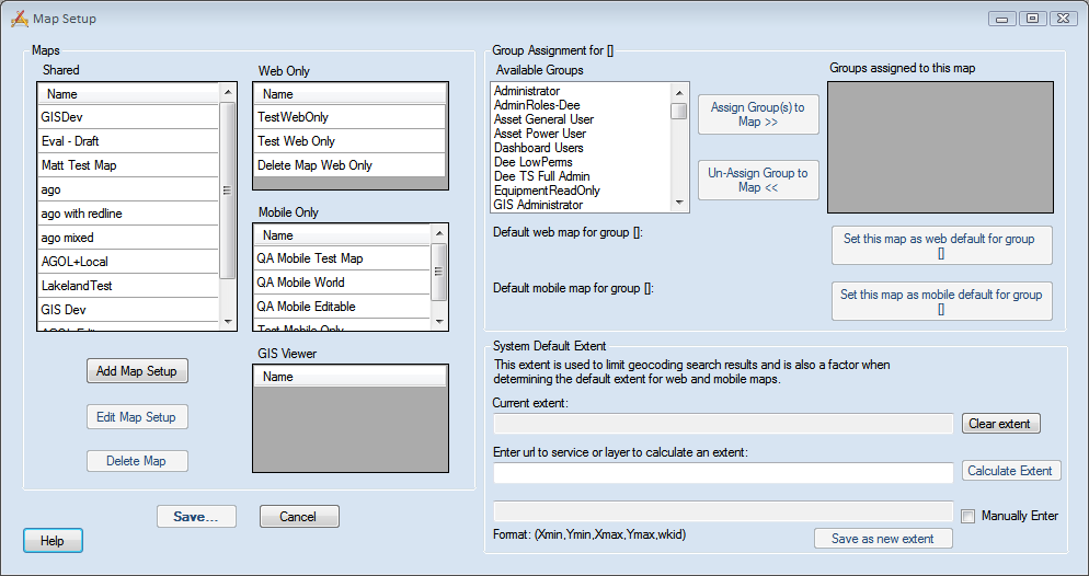
The Map Setup tool enables administrators to define maps and assign them to different groups of users. The process is used to create maps for the Lucity Web Map, Lucity GIS Viewer, and for Lucity Mobile - Map Mode.
Considerations
Which map services should be in this map?
For which mapping product is this map intended?
Maps
This section allows agencies to manage their maps.
Shared
Lists maps that are available for both the Lucity Web and Lucity Mobile applications.
Web Only
Lists maps that are only available for the Web application.
Mobile Only
Lists maps that are only available for the Mobile applications.
GIS Viewer
Lists maps that are available for the GIS Viewer application.
Add Map Setup
Adds a new map.
Edit Map Setup
Edits the map selected in one of the grids.
Delete Map
Deletes the map selected in one of the grids.
Group Assignment for [...]
This section allows agencies to manage which groups are assigned to the map selected on the left.
Available Groups
Lists user groups that could be assigned a default map. This list is populated with the security groups that are assigned as a Default Rules group in the Lucity Security Program.
Assign Map to Groups >>
Assigns the selected map as the default map for the group(s) selected in the Available Groups grid.
Un-Assign Group to Map <<
Removes the association between the selected map and the group(s) selected in the Assigned Groups grid.
Groups assigned to this map
Lists groups assigned to the selected map.
Default web map for group [...]
Indicates the map currently set as the default web map for the group selected in the Available Groups grid.
Default mobile map for group [...]
Indicates the mobilemap currently set as the default mobile map for the group selected in the Available Groups grid.
Set this map as web default for group [...]
Sets the currently selected web map as the default web map for the group selected in the Groups assigned to this map grid.
Set this map as mobile default for group [...]
Sets the currently selected mobile map as the default mobile map for the group selected in the Groups assigned to this map grid.
System Default Extent
This section allows admins to set the default extent of the webmap. This can:
Dictate the location the map is opened to. To force the map to open to this extent every time you must set the Admin Portal > Settings > System Settings > GIS Web > Force the GIS Web Map to always open to the default extent setting.
Current Extent
Displays the extent that is currently selected. The extent can be modified using some of the fields below.
Clear Extent
Clears out the Current Extent field.
Enter url to service or layer to calculate an extent
Indicates the web address for the map service or layer (within a service) used to calculate the Current Extent field. The program will use the URL to copy the service's or layer's Full Extent/Extent and set the Current Extent field.
Calculate Extent
When enabled, calculates the Current Extent from the Enter url to service or layer to calculate an extent field.
Manually Enter Extent
Unlocks the Manual Entry field.
Manual Entry Field
Indicates that the extent should be determined by the parameters provided. Enter the desired extent using the following format:
Xmin, Ymin, Xmax, Ymax, wkid
Save as new extent
Saves the manually entered extent as the Current Extent.
In theLucity Administration Tool, select GIS > Map Setup from the main menu. The map setup appears:
The left side of the dialog displays all available maps. Click the Add Map Setup or select a map and click Edit Map Setup buttons to open the GIS Map Edit screen.
Under Lucity applications that can use this map, select Web & Mobile or Web only.
Check the Use as Default Map box to make this the default map.
Set the Geocoding Url. Enter a URL or path here if the geocoding service used for this map will be different than the one entered in the Default Geocoding Url field. The Default Url is set in the Lucity Administration Tool, under System > Settings on the GIS Web tab.
Select the service that contains your Redline layers.
Use the map services listed in the Available Web Services and the Available Editable Services to populate the Services to Display in Map grid.
Modify the service settings in the Services to Display in Map grid.
Note: The Web Map and Mobile Map tools will recognize Lucity data in all layers as long as the aliases are set up correctly.
Click Close to return to the Map Setup screen.
Once the maps have been defined, click Save on the Map Setup screen.
In theLucity Administration Tool, select GIS > Map Setup from the main menu. The Map Setup appears:
The left side of the dialog displays all available maps. Click the Add Map Setup button or select a map and click the Edit Map Setup button to open the GIS Map Edit screen.
Under Lucity applications that can use this map, select Web & Mobile, or Mobile only.
Set the Geocoding Url. Enter a URL or path here if the geocoding service used for this map will be different than the one entered in the Default Geocoding Url field. The Default Url is set in Lucity Administration under System > Settings on the GIS Web tab.
Select the Redlining layers if you use redlining in your map.
Use the map services listed in the Available Web Services and the Available Editable Services to populate the Services to Display in Map grid.
Modify the service settings in the Services to Display in Map grid.
Note: The Mobile Map tools will recognize Lucity data in all layers as long as the aliases are set up correctly.
Click Close to return to the Map Setup screen.
Select the map in one of the grids in the Maps section.
Select one or more groups you want to access the map in the Available Groups grid.
Click the Assign Groups to Map >> button. The groups will move to the Groups assigned to this map grid and are now able to access to that map.
If the map should be a default map for a group, select the map in the Maps section.
Select the group in the Available Groups grid.
Click the one of the Set the map as... buttons.
Once the maps have been defined, click Save on the Map Setup screen.
Under Lucity applications that can use this map, select GIS Viewer.
Check the Use as Default Map box to make this the default map.
There can only be one default map. If more than one map exists, the Viewer will ask which one to use. The default map will appear at the top of the list.
Set the Geocoding Url. Enter a URL or path here if the geocoding service used for this map will be different than the one entered in the Default Geocoding Url field. The Default Url is set in Lucity Administration Tool, under System > Settings on the GIS Web tab.
The Geocoding Url can be either a URL for a geocoding service OR the path to a geocoding package (.gcpk).
Use the map services listed in the Available Web Services and the Available Local Services to populate the Services to Display in Map grid.
Modify the service settings in the Services to Display in Map grid.
Note: The Lucity GIS Viewer will recognize Lucity data in all layers, as long as the aliases are set up correctly.
Click Close to return to the Map Setup screen.
Assign the map to the desired user groups.
Note: All maps that are marked as GIS Viewer will be visible to all Lucity GIS Viewer users.
Select the map that you want to set as a Default map for a group.
Review the groups in the Groups assigned to this map grid.
If the group you want to assign the map to as a default is not in this grid you need to select the group in the Available Groups grid and click the Assign Group(s) to Map >> button.
Select the group in the Groups assigned to this map grid.
To set the map as the group's default web map click the Set this map as web default for group [...] button.
To set the map as the group's default mobile map click the Set this map as mobile default for group [...] button.
Note: These buttons are grayed out if an incompatible map is selected.
When the user opens the web map it will default to the map listed under Default web map for Group [...].
When the user opens the mobile map it will default to the map listed under Default mobile map for Group [...].
Note: Because each group can have a default map, and each user can have multiple groups the web and mobile maps will use the default map assigned to the user's Default Rules Group. Each user can only have one Default Rules Group, which is assigned in the Lucity Security program.
 How to set up a Web Map