![]()
The Data Table enables users to see information about and interact with:
The table automatically opens when the Selection tool or Show Work Locations tools are used.
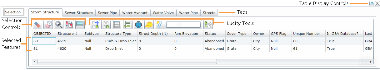
Table Display Controls
Above the table, on the right, are two buttons that control the table's appearance:
|
Expands the table and shows more records |
|
Closes the table, but does not clear the current selection. |
|
|
Tabs
A row of tabs appears at the top of the table grid. Each tab corresponds to a feature class that has features included in the current selection. Click on a tab to switch to a table showing the selected features for that feature class.
Graphics created using the Create Work Point tool are displayed on a tab called UserPointGraphics.
|
Selected Records
Features that appear in the table are currently selected. They are displayed in the map using the Main Selection Color.
Note: Use the Display Preferences tool to change the Main and Secondary Selection Colors.
|
Selection Controls
The Selection controls are used to manipulate the current feature selection.
|
|
Clear Selection |
Deselects any features that are currently highlighted in the table and removes them from the Data Table. |
|
|
Clear Highlight |
Removes the highlight from any records that are currently highlighted in the table. However, these records do remain selected. |
|
|
Zoom and Flash Highlight |
Zooms to the features highlighted in the table. |
|
|
Switch Highlight |
Switches which records are highlighted in the table. Any records that are currently highlighted will not be; any records that were not highlighted will be. |
|
|
Highlight All In Selection |
Highlights all records in the current table. |
|
|
|
|
Lucity Tools
The Lucity Tools enable users to perform Lucity operations against features in the map.
Note: To use these tools users must high light one or more features in the table.
|
|
Attaches the currently selected or currently highlighted assets to an existing subset. |
|
|
|
Creates a subset using the currently selected or currently highlighted assets. |
|
|
|
Shows all Lucity modules and records related to a highlighted asset. Users can then jump to a related module. |
|
|
|
Shows relationships between the selected record and records in other modules based on address. |
|
|
|
Enables users to view documents attached to a highlighted feature and/or attach new documents. |
|
|
|
Creates a Request for a highlighted asset. |
|
|
|
Creates a Work Order for all highlighted assets. |
|
|
|
Attaches highlighted assets to a existing Work Order. |
|
|
|
Create PM/Template |
Creates a standard PM/Template for all highlighted assets. |
|
|
Creates an Inspection for the currently selected asset. |