
 Print
Print
|
|
|
|
|
Data Table
Click the Data Table tool ![]() to view the features that are selected in the map.
to view the features that are selected in the map.
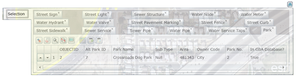
This dialog lists all features and their attributes at the location that you clicked. This tool will only work for visible layers. Different types of features will be listed in separate tabs.
Several additional tools are included with the Selection dialog. These are described below:
- Click
 to clear the selection from the data table.
 - Click
 to clear the highlighted feature(s) in the map.
 - Click
 to zoom and flash highlight the selected features in the map.
 - Click
 to switch selection from the currently selected features to the assets that are not selected.
 - Click
 to highlight all of the selected features in the map.
 - Click
 to view relationships in the web app or in the desktop app.
 - Click
 to create a new subset.
 - Click
 to add to an existing subset.
 - Click
 to expand the data table.
In This Section |
See Also |
Print
| © Lucity, Inc. All rights reserved. |
|