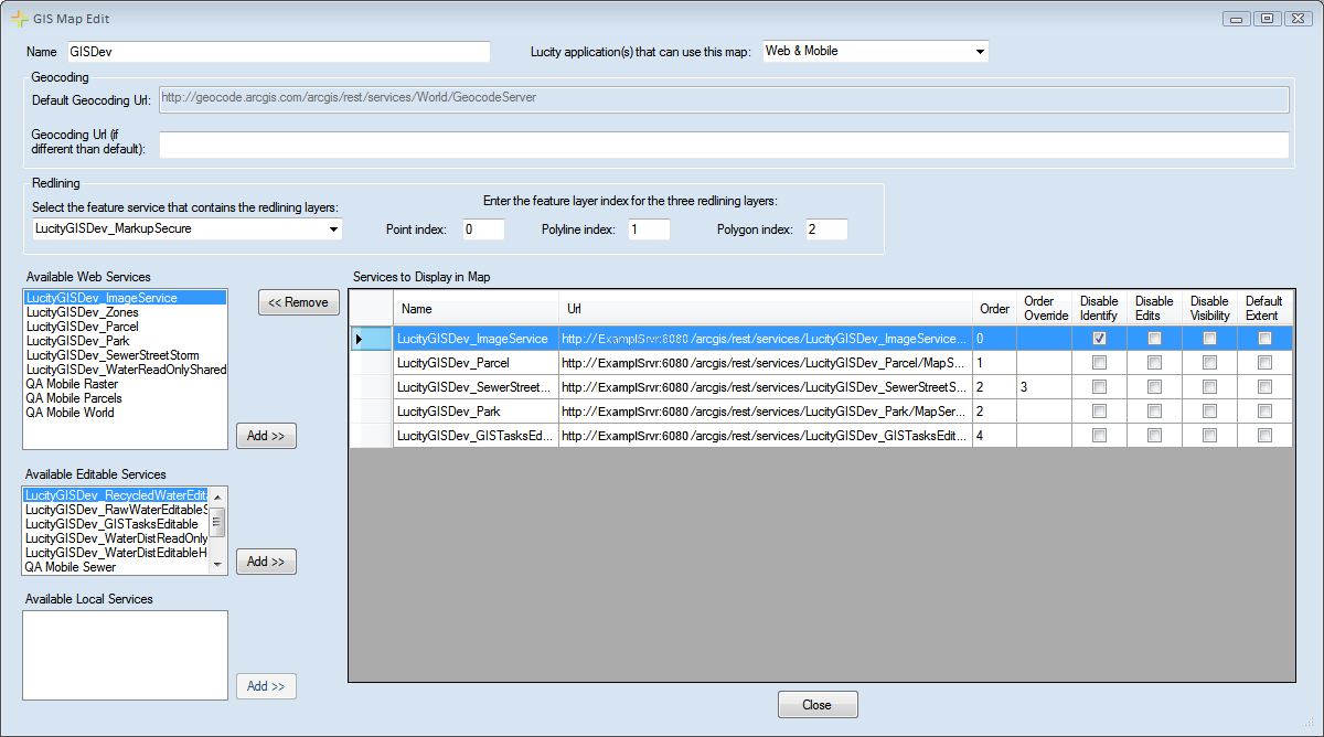
The Map Editor screen allows administrators to design a map using the map services they have configured.
Name |
Specifies a unique name for the map. |
Lucity application(s) that can use this map |
Indicates which Lucity mapping program this map is designed for. This interface is used to create maps for Lucity Web and Lucity Mobile.
|
Geocoding
Specifies which geocoder the map will use.
Default Geocoding URL |
This is the default geocoder that the map will use if you don't select another one. This is set in the URL for Geocoding Service ... setting under System > Settings > GIS Web tab. |
Geocoding URL (if different than default) |
Enter a URL here if the geocoding service used for this map will be different than the URL in the Default Geocoding Url box. |
Redlining
Controls which redlining layers appear in the map. The names of the Redlining layers must also be added to the GIS Services > Redlining Aliases tab.
Select the feature service that contains the redlining layers |
Select the Redlining map service from the drop-down if users need to use the redlining tool in the map. (This list only displays the feature services configured in the Map Services tool.) |
Point Index |
Indicates the number for the redlining point layer in the redlining map service. |
Polyline Index |
Specifies the number for the redlining line layer in the redlining map service. |
Polygon Index |
Indicates the number for the redlining polygon layer in the redlining map service. |
Available Services
Available Web Services |
Lists all web map services (those services entered into the Map Services tool that do not have the Has Feature Service box checked). |
Add >> |
Adds the map services selected in the Available Web Services list to the map. The services will appear in the Services to Display in Map list. |
Available Editable Services |
Lists all editable web map services (those services entered into the Map Services tool that have the Has Feature Service box checked). |
Add >> |
Adds the editable map services selected in the Available Editable Services list to the map. The services will appear in the Services to Display in Map list. |
Available Local Services |
This section is no longer used. |
Add >> |
This button is no longer used. |
Services to Display in Map
Lists all of the map services that are in the map.
Name |
Displays the name of the map service. |
URL |
Displays the URL/path to the map service |
Order |
Displays the default sequence of the layers, based on the Order entered in the Map Services tool. |
Order Override |
Allows the user to adjust the sequence of layers for this map by ordering the items in this column. 0 is the lowest layer in the map. |
Disable Identify |
Prevents users from identifying or selecting features in a map service. |
Disable Edits |
Prevents users from editing a specific map service in this map. |
Disable Visibility |
Hides the selected map service. Services with visibility disabled are turned off when the map is initially accessed; however, users can turn them back on. Disabling visibility of map services makes the map load faster. |
Default Extent |
Marks a single layer as the default extent. That is, the service's extent will be the default extent for the entire map when it is loaded. |
<< Remove |
Removes the service selected in the Services to Display in Map list. |
Close |
Closes the Map Editor. |