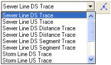
Sewer and Storm lines may be traced using the Lucity Trace Solver tool and the Trace Task drop down list on the Lucity GIS Toolbar.

There are several traces available for sewer and storm lines:
Trace Type |
Description |
Upstream Trace |
Selects all lines upstream of the line that is clicked on, including the line that is clicked on. |
Downstream Trace |
Selects all lines downstream of the line that is clicked on, including the line that is clicked on. |
Upstream Distance Trace |
Prompts for a distance to trace. Traces upstream until that distance is met or exceeded. The line that is clicked on is included in the distance calculation. It does not matter where on the initiating line you click; the system will take the full line length in the calculation. |
Downstream Distance Trace |
Prompts for a distance to trace. Traces downstream until that distance is met or exceeded. The line that is clicked on is included in the distance calculation. It does not matter where on the initiating line you click; the system will take the full line length in the calculation. |
Upstream Segment Trace |
Prompts for the number of segments to trace. Traces upstream until the specified number of segments are selected. The line that is clicked on is included in the segment count. |
Downstream Segment Trace |
Prompts for the number of segments to trace. Traces downstream until the specified number of segments are selected. The line that is clicked on is included in the segment count. |
Selection > Zoom to Selected Features.