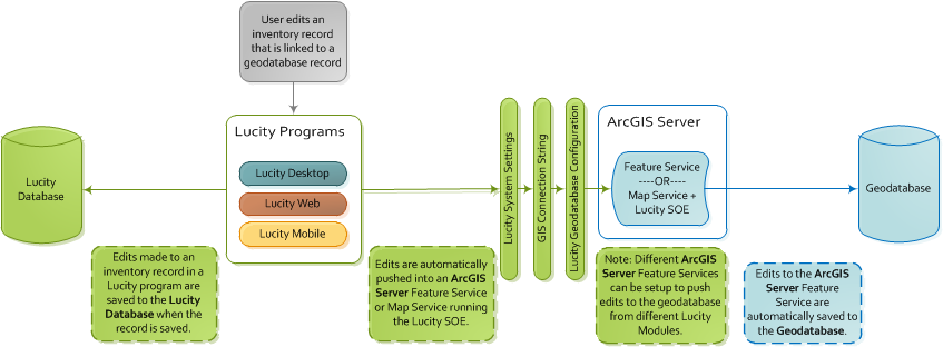
The Lucity-to-geodatabase integration allows edits made in LucityInventory modules to be pushed to the geodatabase.
Note: An agency that uses GIS must complete this configuration if it wants to allow Lucity to update the geodatabase.
Process
Inventory Edits
Edits made in the Lucity interface are pushed directly into the Lucity database.
During the push, the program checks the Lucity settings to determine how it should connect to the geodatabase.
If the integration is configured to use a feature service, the program will push updates into the feature service, which then automatically updates the geodatabase.
If the integration is configured to use the Lucity SOE (service object extension), the program will connect to the map service. The Lucity SOE enabled on the map service then pushes updates to the geodatabase.
Setup
There are two ways to set up this integration: 1) using a feature service, or 2) using a map service. The suggested method uses a feature service as this is based on ESRI's newer more robust technology.
Complete one of the following configuration processes to establish a default link between Lucity and the geodatabase.
Feature Service
A feature service is usually the primary link between Lucity and the geodatabase. Feature services are map services published through ArcServer that have feature access capabilities enabled. An administrator adds a feature service to the Lucity connection string using the Lucity Administration Tool, which is locatedunder GIS > Connection Strings.
If collecting information for the map service that contains your operational data, click on the REST URL. A page containing the properties of the map service appears.
Scroll down and copy down theSpatial ReferenceNumber. (Do this only for the layer that contains Lucity data.)
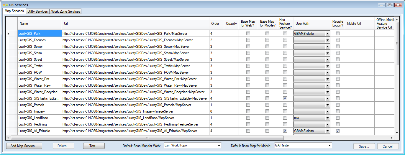
Launch the Lucity Administration Tool and select GIS > GIS Services.
On the Map Services tab click the Add Map Service button.
Enter a Name and the REST URL of the map service.
Note: This URL should end in /MapServer.
Check the Has Feature Service? box. This tells the map that the layer has an attached Feature Service.
Fill out other fields as necessary.
Click the Save button.
Note: If you are modifying an existing map service to have editing capabilities you just need to mark Has Feature Service? box for the existing record in the Map Service setup.
Close the GIS Services tool
Point Lucity to the feature service.
Open Lucity Administration Tool > GIS > Connection Strings.
Find the connection string that links to the same data that the feature service does.
Use the Editable Map Service dropdown, select the map service that you added to the map services grid.
Configure Lucity to recognize that it is using a feature service.
Open Lucity Web > Admin Portal > Settings > System Settings > GIS Edit Integration section.
Make sure the Use Feature Service instead of Lucity SOE setting is set to TRUE.
Users need Lucity App Admin > Run permission to access this section of the Lucity Administration tool.
Map Service
A map service with the SOE (service object extension) can also create a link between Lucity and the geodatabase. A map service contains feature class and database connection information that is published through ArcServer. When the Lucity SOE is enabled on a map service, its connection information passes information from Lucity to the geodatabase.
Although using a map service is an older method, it is still a viable option. However, an agency should not implement this integration method if it plans to use feature services and GIS tasks to push edits from the Lucity Webmap (or other GIS editing platforms) to the Lucity Database. More information on GIS Editing outside of ArcMap
This map service must contain at least one feature class from the geodatabase that contains the features that Lucity will update. It is acceptable for the map service to contain all of the feature classes that could be updated; however, this is not required.
The map service does not need any additional non-Lucity feature classes.
You can either use a new map service or an existing one.
The map does not need to be included in any Webmaps.
The map service does not require any special symbology.
The user account used to add the data to the map service must have edit permissions for the feature classes that Lucity will update in the geodatabase.
The map service must point to the version of the geodatabase that Lucity should update.
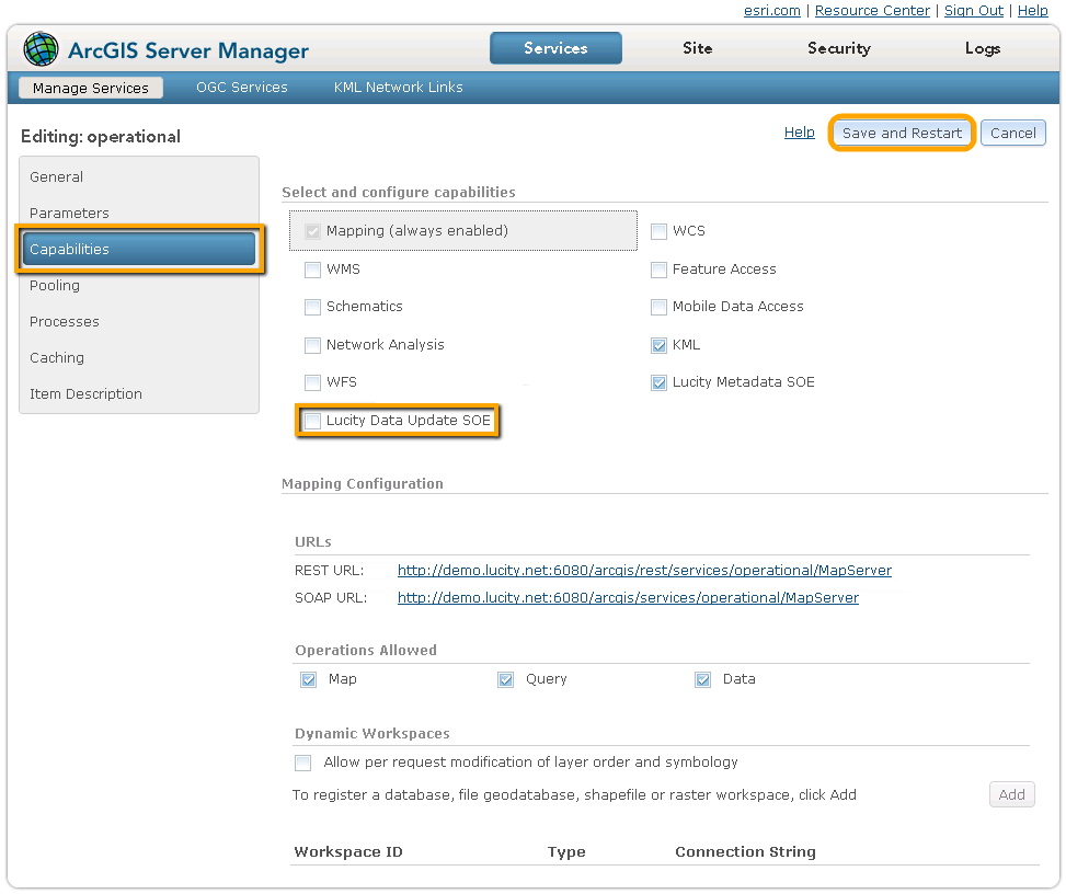
Enable the SOE for the map service.
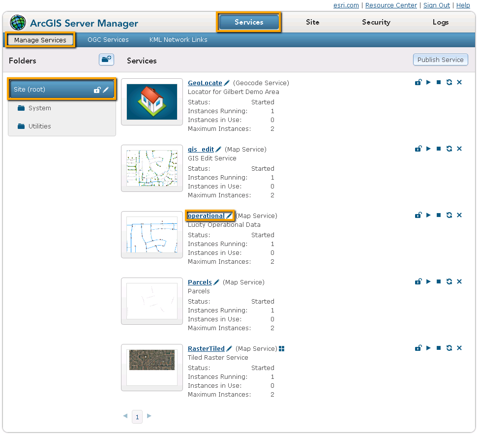
Log into Arc Server Manager and click on Services > Manage Services.
Log into Arc Server Manager, and, in the toolbar, select Services > Manage Services.
Find a map service to use.
Click on the map service to view its properties.
Click the Capabilities button.
Copy down the REST URL, which should have a path similar to: http://<server name>/ArcGIS/rest/services/<service name>/MapServer.
Point Lucity to the map service.
Open Lucity Administration Tool > GIS > Connection Strings.
Find the connection string that links to the same data that the map service does.
Under Edit Map Service URL, add the REST URL for the map service to the connection string.
If the map service is protected, complete the Map Service User and Map Service Password fields by providing a username and password for an ArcGIS account that has permission to edit the data used to create the map service.
Configure Lucity to recognize that it is using a map service.
Open Lucity Web > Admin Portal > Settings > System Settings > GIS Edit Integration settings.
Make sure the Use Feature Service instead of Lucity SOE setting is set to FALSE.
Users must have the Lucity App Admin > Run permission to access this section of the Lucity Administration tool.
Relevant Settings
Settings that affect this integration are found in Lucity Web, under Admin Portal > Settings > System Settings > GIS Edit Integration section.
Optional Setup
Alternate Feature Services
While the integration instructions outlined above create a default link between Lucity and the geodatabase, an agency can also set up alternate links between Lucity and the geodatabase. Doing so allows an agency to divide its feature classes into different feature services.
Using alternate feature services is not necessary; however, feature services are also used to establish edit capabilities in the Webmap and other web-editing platforms. Feature services used for Webmap editing are typically small and contain feature classes from only one set of GIS data (e.g., Storm features). Therefore, multiple editing feature services are required for different types of data.
In such a situation, an agency can reuse its editing feature services as alternate feature services within the geodatabase configuration.
Create the feature service using ArcMap. Keep in mind:
The map service must contain the feature classes that you want it to update in the geodatabase.
The feature classes must display all of the fields that are configured to link to Lucity.
The map service does not need any additional non-Lucity feature classes.
You can either use a new map service, or an existing one.
The map service does not require any special symbology.
The user account used to add the data to the map service must have edit permissions for the feature classes that Lucity will update in the geodatabase.
The map service must point to the version of the geodatabase that Lucity should update.
If collecting information for the map service that contains your operational data, click on the REST URL. A page containing the properties of the map service appears.
Scroll down and copy down theSpatial ReferenceNumber. (Do this only for the layer that contains Lucity data.)
Launch the Lucity Administration Tool and select GIS > GIS Services.
On the Map Services tab click the Add Map Service button.
Enter a Name and the REST URL of the map service.
Note: This URL should end in /MapServer.
Check the Has Feature Service? box. This tells the map that the layer has an attached Feature Service.
Fill out other fields as necessary.
Click the Save button.
Note: If you are modifying an existing map service to have editing capabilities you just need to mark Has Feature Service? box for the existing record in the Map Service setup.
Close the GIS Services tool
Configure the feature class(es) to use an alternative feature service.
Single Feature Class/Single Alternative Feature Service:
 How to configure the feature service