This window is to provide Lucity with connection strings to connect to ArcGIS geodatabases. Connection strings have two purposes. They allow Lucity to connect to a geodatabase and update the attributes of feature class records that are linked to Lucity. They also help the Lucity GIS tools in ArcMap to identify which feature classes are linked to Lucity.
To access the connection strings window in the Lucity Administration tool go to GIS > Connection Strings. The following window will appear.
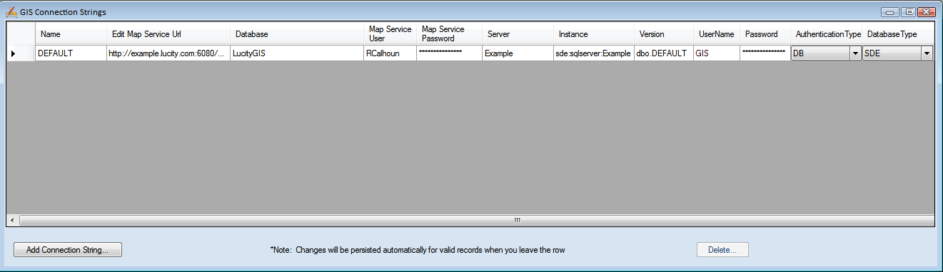
Name |
The user defined name of the connection string. The first one MUST be called DEFAULT. This connection string should point to geodatabase that contains the feature classes linked to Lucity. Note: To connect to the Live Data Tool there must be a connection string call LIVEDATA. |
Edit Map Service URL |
This is the url for a map service that is used by Lucity Desktop or Web to update feature class attributes in the SDE geodatabase. For more information go here. |
Database |
SDE - The name of the SQL SDE geodatabase. When using an Oracle SDE leave this field blank Personal or File - the path to the geodatabase, including the geodatabase. (Example - R:/GIS/Lucity/LucityGIS.gdb) |
Map Service User |
If the Edit Map Service URL is for a secured map service enter user name that has permissions to access the service. |
Map Service Password |
Enter the password for the Map Service User. |
Server |
SDE - The name of the server that holds the SDE Personal or File - leave blank |
Instance |
SDE - The name of the instance that holds the SDE. This supports either spatial, or direct connections. Personal or File - leave blank |
Version |
SDE - The name of the SDE version that Lucity will use to connect to the geodatabase. Personal or File - leave blank |
UserName |
SDE - The database login that Lucity will use to connect to the geodatabase. Only enter if the Authentication Type is set to DB. Personal or File - leave blank |
Password |
SDE - The password that Lucity will use to connect to the geodatabase. Only enter if the Authentication Type is set to DB. Personal or File - leave blank |
Authentication Type |
SDE - How Lucity will connect to the database.
|
Database Type |
The Type of Geodatabase, SDE, File or Personal. |
Note: An exclamation point in the left-hand margin indicates a bad connection.