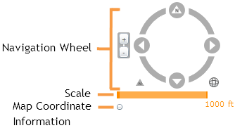
Navigation Wheel - click on different parts of the wheel for different functions.
- Click the four arrows on the wheel to move the map North, East, South, and West.
- Click and drag the other areas of the compass to rotate the map in any direction.
- Click the arrow to the lower-left of the compass to reset the map to North.
- Click the globe icon to the lower-right of the compass to zoom to the full extent.
- Click the + and - buttons to the left side of the compass to zoom in or zoom out in the map
- Along with these functions users can:
- Hold down the
Shiftkey, click and drag the mouse to zoom to a selected area in the map. - Use the navigation tools on the Map Management Toolbar
- Hold down the
Scale - Shows the scale the map is currently at. This changes as users zoom in and out.
Map Coordinate Information - After clicking this button XY information will appear in the lower left corner for wherever the mouse point is currently pointing. It will also displays the map WKID. Click this button again to turn off.