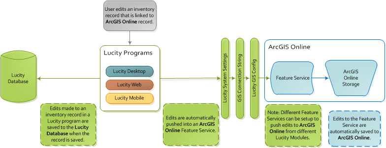
The Lucity-to-ArcGIS Online integration instructs Lucity Web/Mobile GIS tools to:
recognize ArcGIS Online data as linked to Lucity, and
allow edits made in LucityInventory modules to be pushed to ArcGIS Online.
This is a recommended configuration for all agencies as it is required for many Lucity tools to work properly. It can be configured so that edits are not passed to the geodatabase.
Note: Agencies that use GIS must complete this configuration.
Process
Inventory Edits
Edits made in the Lucity interface are pushed directly into the Lucity database.
During the push, the program checks the Lucity settings to determine how it should connect to ArcGIS Online. Then the program pushes updates into the feature service, which automatically updates ArcGIS Online.
Setup
ArcGIS Online uses feature services to display information. These feature services form the primary link between Lucity and ArcGIS Online.
Most of the Lucity-to-ArcGIS Online configuration is completed using the GIS Config tool. For complete instructions, see the guide for the GIS Config tool.
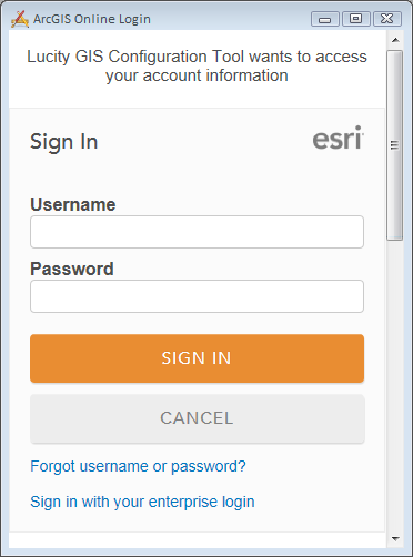
In the Administration Tool, select GIS > GIS Config. The ArcGIS Online Login window appears.
Enter your ArcGIS Online Username and Password and click Sign In.
The tool connects to your ArcGIS Online account and displays a list of the services available to you.
Note: Your login must be associated with your agency inside ArcGIS Online.
At this point the system will automatically create and save the connection to the ArcGIS Online account in the Lucity Administration Tool under GIS > Connection Strings.
Each feature layer that an agency wants to link to Lucity must be contained in one or more of its ArcGIS Online services.
Each feature layer that an agency links to Lucity must have a unique, user-friendly name. This name is used whenever the feature layer is included in a service that Lucity references.
The feature layers must display all of the fields that an agency wants to link to Lucity.
The service does not need any additional non-Lucity feature layers.
The service can either be a new service or an existing one.
This service does not need to be included in any Webmaps.
This service does not require any special symbology.
 How to point Lucity to an ArcGIS Online account