
 Print
Print
|
|
|
|
|
Identify Features
When using the ![]() Identify Features tool in the web map, first click the tool, then click on a location in the map. A dialog similar to the following will appear:
Identify Features tool in the web map, first click the tool, then click on a location in the map. A dialog similar to the following will appear:
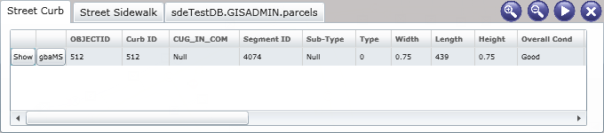
This dialog lists all features and their attributes at the location that you clicked. This tool will only work for visible layers. Different types of features will be listed in separate tabs. As you can see in the example above, the click location contained street curb, street sidewalk, and parcel features.
Several additional tools are included with the Identify dialog. These are described below:
 Click the Show button and the selected feature will be highlighted in the map
 Click the gbaMS button to launch the feature relationships dialog. This dialog lists all gbaMS records associated with the selected feature. For example, the feature below has one associated Curb Inventory record, one associated Work Order record, and one associated Work Request record.
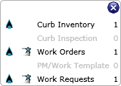
- Click the
 icon beside the module name to launch the record(s) in the gbaMS Desktop application.
 - Click the
 icon beside the module name to launch the record(s) in the gbaMS Web application. If you launch the web map from a web form, it will use the same web form to display the record. If you launch the web map from the Dashboard, it must have a default form selected in the gbaMS Administration for Web Apps Form Manager in order to be displayed.
- Click the
 Increases the font size in the Identify dialog.
 Decreases the font size in the Identify dialog.
 Expands the size of the dialog. This function is only available if the browser is at least 1400 pixels wide.
 Closes the Identify dialog.
See Also |
Print
| © GBA Master Series, Inc. All rights reserved. |
|