Management Tools
These options control how the tool is going to operate.
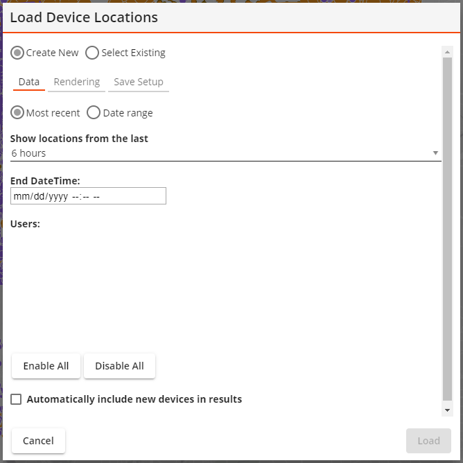
Create New Select Existing |
Indicates that the tool is creating a new layer or is using an existing layer. |
Existing Setup* |
Enables the user to select a saved layer. |
|
Causes the Existing Setup list to only show layer setups that are currently set to always show up in the current gis view. |
|
Causes the Existing Setup list to only show layer setups that were created by the currently logged in user. |
* Only appears if the Select Existing option is selected.
Time
These options filter the data shown based on the time.
Show most recent locations |
Displays device locations for a previous number of hours. |
|
Sets the number of hours back in time the layer will show. |
Show Locations that Fall within a date range |
Displays the device locations for a range of dates.
|
|
Sets the start of the date range. |
|
Sets the end of the date range. |
Devices
These options filter the data shown based on the user logged into a device.
Users |
Displays a list of mobile users. Selects which users location history the layer will display. |
Enabled All |
Adds all users in the list to the results. |
Disabled All |
Removes all users in the list from the results. |
Automatically include new devices in results |
Enables new users in the list when their devices begin tracking location information. |
Rendering: Layer Properties
The last section of the tool lets the user control the layer that will be added to the webmap.
Layer Title |
Indicates the name of the map layer that this tool will create. Users may edit the name generated by the system. |
Field Color Palette Assign Colors |
Enable the user to control how each user's location is symbolized.
|
Symbol Size |
Controls the size of the symbols that will appear in the map. |
Auto Refresh Interval |
Tells the system to automatically refresh the data in the layer based on the number of entered minutes.
|
Saved Setup Properties
Lucity Device Location Layers can be saved and loaded at a later time.
Setup Name |
Provides an ID for the configured layer so that it can be saved in the system and found later. |
Setup Description |
Provides an optional description of the purpose of the layer. |
Buttons
These buttons control what is done with the configured module spatial layer setup.
Cancel |
Closes the tool without doing anything further. |
Remove |
Removes the setup from the current GIS View. Only available if the setup in the Existing Setup is currently assigned to the current GIS View. |
Delete |
Deletes the setup record and closes the tool. |
Save |
Saves the setup. The Setup Name field must be populated. |
Assign |
Assigns the setup listed in the Existing Setup field to the current GIS View. The layer will be loaded every time the view is opened. |
Load |
Loads the Setup into the webmap. |