 and select Update GIS Values. The following pop-up will appear:
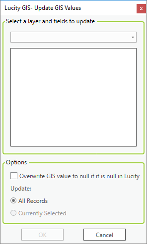
This tool is designed to allow users to rapidly update the values in a feature class with the values from a related Lucity module. This tool is helpful if a new field has recently been added to a feature class and linked to a populated Lucity field. This will update the geodatabase to be in sync with Lucity. It also is useful for organizations that use File or Personal geodatabases. Due to ESRI restrictions the link between Lucity and a File or Personal geodatabase only works from ArcMap to Lucity. This tool provides a way to push changes made in Lucity to the feature class.
How To Update a geodatabase value
and select Update GIS Values. The following pop-up will appear: