When working with large amounts of data and integrating that data between two systems there is always the possibilities of errors. The QA/QC tool helps identify possible problems within layers in the map. The tool workes for all layers in the map whether they are linked to Lucity or not.
Validations Performed
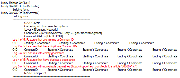
Features that are missing a Facility ID - These features are in the gis system, but cannot be sync'd to Lucity.
Features that have duplicate Facility IDs - If two features have the same Facility ID they will link to the same record in Lucity. So two features (possibly at different locations) will be pointed to the same Lucity record.
Features with empty geometries - Features that exist in the feature class' attribute table, but have no spatial reference in the map.
Features that have duplicate geometries - Two features that are in exactly the same spot in the map. Note that these might not always be errors. For example two street signs may be attached to the same pole.
Features with complicated geometries - A feature with geometry that is formed incorrectly, for example a line that crosses itself.
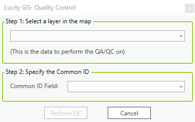
In ArcGIS Pro, Click on the button. The QA/QC form will appear
In the Step 1 section click the drop down arrow button to choose the map layer that needs to be checked.
In the Step 2 section specify the layer's common id field in the drop down box.
Click Perform QC and the results will popup in another window. See result examples below:
The red line describes which part of the QC is being performed. Each section will provide a list of features and at least the OID so that they can be found in the gdb.

 How To Run and Read the QA/QC tool
 button. The QA/QC form will appear