This Layer Info tab displays basic information about the feature class, as well as its linking fields and certain diagnostic fields.
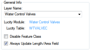
General Information
Layer Name: |
Identifies this particular feature class layer in the feature service. |
Lucity Module: |
Indicates the Lucity module with which the layer is associated. (This field is read-only.) |
Lucity Table: |
Identifies the Lucity database table that stores information for the selected Lucity module. (This field is read-only.) |
Disable Feature Class: |
This flag disables a feature class layer that is not in use, but needs to remain in the setup. It is recommended to disable any feature class layers that are not being used; it will speed up processing time. |
Always Update Length/Area: |
When enabled, directs the Lucity GIS Extension to update the field in the feature class that is mapped to the Lucity Length/Area field when the shape of a feature changes. If disabled, the Length/Area fields are populated only when the feature is first created. |
Layer Fields (Not linked to Lucity)
This section contains optional fields used to keep track of changes in Lucity. The only exception is the Field for Display.
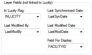
In Lucity Flag Field |
This field is updated by Lucity to indicate whether or not a record in the feature class has been synchronized with Lucity.
|
Last Modified By |
This field is controlled by Lucity to indicate the last user to modify the record in the map.
|
Last Modified Date |
This field is controlled by Lucity to indicate the last date the record was modified in the map.
|
Last Synchronized Date |
This field is controlled by Lucity to indicate the last date the record was synchronized with Lucity.
|
Field for Display |
|
Feature Class Linking Fields
This section is a quick reference to show which fields in the feature class layer form the basis of the link between the layer and the Lucity module.
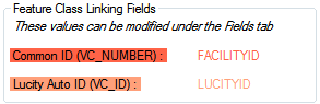
Common ID Field:* |
The unique identifier assigned by the user for this asset. The value for this field cannot be directly modified; it is automatically populated based on the field mappings on the Fields tab. Every module has at least one field that defines the asset as unique. These fields are highlighted in red on the Fields tab. To enter a value in this field go to the Fields tab, find the corresponding red highlighted field, and type the field name into the Feature Class Field Name column. Note: This field should be a string field in the geodatabase, not a numeric field. |
Lucity AutoID Link: |
This field is used by Lucity to store an indexed long integer link between the records in the feature class and the records in the Lucity inventory table. This field must be long integer. The value for this field name is not editable; to update this value, use the grid on the Fields tab. Note: While this field is not required it is still strongly recommended to have it. Not having this field will impact the performance of some of the Lucity GIS tools as additional resources will be used to determine the AutoID value based upon the Facility ID/Common ID. |
* Required
Service Info
This section displays the URL for the Feature Service that contains the Layer.
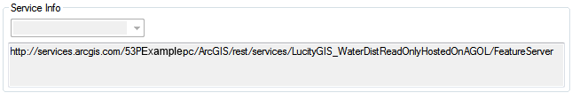
This path is just for information. It is read-only.