The feature class fields grid is designed to link the feature class to Lucity field mappings. A mapping enables the Lucity application to update the feature class when the data is updated in the Lucity desktop or web application. A mapping also enables the Lucity extension in ArcMap to update the Lucity database when the data is updated in the feature class during an ArcMap edit session.
Note: GIS Fields that link to a Lucity Picklist field can only link to the Code portion of the Lucity Picklist field.
Note: Never link Esri's Shape.Length field to the Lucity length field.
Fields
Column Purposes
FieldName:
The field name in the Lucity table.
DisplayName:
The field caption in Lucity.
Field Type:
The type of data stored in the field.
MaxMask:
The data format. A numeric value followed by an "x" indicates the number of characters allowed. n indicates a numerical digit.
Feature Class Field Name:
This is the name of the field in the feature class. This is NOT the alias field name.
Field Lookup:
This button column displays a list of the feature class fields. Note: If a connection to the geodatabase was unsuccessful then no fields will be listed.
Color Coding
Red - Required field
Orange - Stores the required ID numbers of related features.
Yellow - Stores the optional ID numbers of related features.
Green - Composite address field.
Special Fields
X/Y - The X Y fields in Lucity are available for people to map to. However, if they remain unmapped, they are automatically updated using the feature's XY coordinate.
Address fields are made up of multiple components and can be linked using 2 different configurations
Components
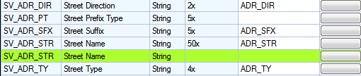
Lucity breaks out street address information into the following fields.
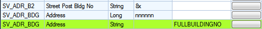
Building Number - The address
Building Number 2 - Extended information about the address (1/2, A, etc...)
Street Direction
Street Prefix
Street Name
Street Suffix
Street Type
Multiple field configuration
In this configuration the feature class has all of the different building number and street name fields broken out. This is configured by linking each field in the feature class to each field in Lucity
Building Configuration
Street Name Configuration
Single Field configuration
In this configuration the feature class has the building number fields combined and the street name fields combined. This is configured by linking the field in the feature class to the special composite field in the geodatabase configuration
Building Configuration
Street Name Configuration
Combined Configurations
These configurations can be used together but both configurations for the same component cannot be used together.
Examples that work
Single Field Building Configuration + Single Field Street Name Configuration
Single Field Building Configuration + Multiple Field Street Name Configuration
Multiple Field Building Configuration + Single Field Street Name Configuration
Multiple Field Building Configuration + Multiple Field Street Name Configuration
Examples that don't work
Multiple Field Street Name Configuration + Single Field Street Name Configuration
Single Field Building Configuration + Multiple Field Building Configuration
How to Link a feature class field to a Lucity field.
Decide which field should be linked.
Look at the field in Lucity. Either get the field display name or CTRL + Right -click and look at field properties for the field name.
In the geodatabase configuration select the feature class linked to the correct module
Search through the grid on the right for the Lucity field using the field name or display name.
Enter the geodatabase field name in the Feature Class Field Name field OR push the Field Lookup button for a list of fields from the associated feature class.

 Address Fields