The first attribute tab records general information about the loss such as its reason, cause, and type. For further location description, two text-fields are available. Additionally, there are check-boxes to indicate whether a locate is needed, whether the loss is billable to another party, and whether damage occurred. This tab also includes an Associations grid. A sample of this grid appears above. This feature allows you to link any assets that could have caused or are related to the water loss. For example, if a hydrant ran over, you could associate the individual hydrant record number to this Water Loss record.
Note: In order to view the location of features contributing to or participating in a water loss event in GIS, the features must be defined in the Associations grid. GIS can also display the address of the water loss if defined.
To add a record in this grid, complete the following steps:
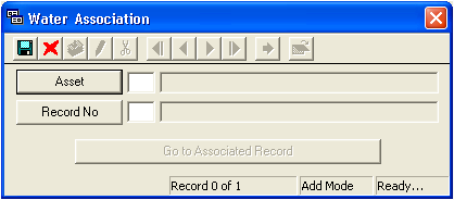
Right-click in the grid and select Add Record. The following window will appear.
Click on the Asset button to select an asset category from the pick list. This list will include all other water assets in the Water Inventory modules (valves, nodes, hydrants, vaults and structures, etc.).
Then, click on the Record No. button to select a specific asset from the pick list. This list will be limited by the asset category you chose above. For example, if you selected Vaults/Structures as the asset, only individual vault/structure records will be included in this pick list.
Click to save the record.
Click to exit Add Mode.
Click to close the window.
Note: After re-opening the record in the grid, the Go to Associated Record button will be enabled. This button opens up the individual asset record that you selected from the Record No. pick list.
 to save the record.
 to exit Add Mode.
 to close the window.