This tab contains a grid that records all street segments associated with the structure. You can sort the records in this grid by clicking on the headings. An up or down arrow (circled in red below) will appear signifying ascending or descending order. Click the heading again to change direction. You can add records to the grid as well as view, edit, or delete existing records.
Adding Records
You can associate street segments with the structure by completing the following steps:
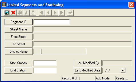
Right-click in the grid and select Add Record. The following window will appear:
As the structures are tied to segments, you cannot add a Segment ID that does not already exist. For information on creating new segments, please reference the Segment Network help guide. To associate an existing segment with your structure, use one of the following three methods:
Type an existing value into the Segment ID field,
Use F9 to view a "pick list", or
Click on the Segment ID button to select a value.
Once a Segment ID has been selected, the system will automatically fill the corresponding data into the Street Name, From Street, To Street, and District Name fields.
Record the Start Station and End Station in the fields provided.
The Last Modified By and Last Modified Date fields are generated by the system. These fields provide a date stamp that cannot be altered by the user.
Click to save the record.
Click to close the window.
Viewing, Editing, or Deleting Records
To view, edit, or delete existing segments from the grid, Right-click on the record and select View Record, Edit Record, or Delete Record.
 to save the record.
  to close the window.