Setup: Esri Citizen Reporter Integration
Lucity support with Esri’s Citizen Reporter application. This integration generates Lucity Work Requests based on new problems reported through Esri’s Citizen Reporter interface. This guide walks through the steps necessary to configure Lucity GIS scheduled tasks to work with Citizen Reporter GIS services.
The following configuration must be completed for each citizen reporter problem layer.
Prerequisites
The Lucity GIS configuraiton is complete. Configuration of Esri's Citizen Reporter app is complete and the Citizen Reporter GIS service layers use Esri's predefined schema.
Open the Lucity Administration Tool. If the service is secured go to GIS > Authentication Setup . If it is not secured skip to step 3.Click the Add User button and enter the following information on the new row that appears:Name/Desc - Enter a unique name for the Username - The ArcGIS user that has access to the Citizen Reportder serviceSet Password - Click this button and enter the password for the Username. In the Lucity Administration Tool go to GIS > GIS Services . Click Add Map Service and enter the following in the new row that appears:Name - a unique name of the service. ex CitizenReporter_AnimalProblems.URL - The URL for the Feature Service.User Authentication - If the service is security select the user you added in step 2.
In ArcCatalog open the Geodatabase Configuration tool. Right-click on the Geodatabase node and select Add Feature Class .
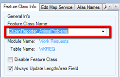
From the inventory module drop down list select Work Requests. In the center pane of the geodatabase config enter the name of your Citizen Reporter feature class.
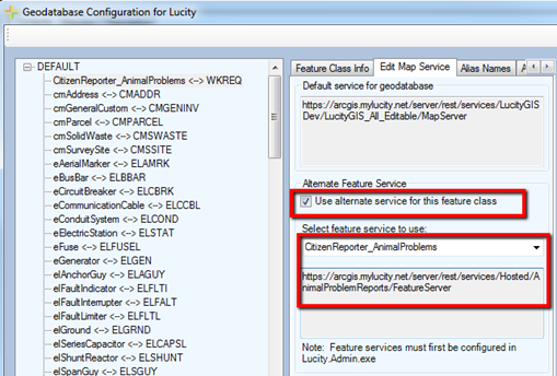
Click onto another layer's node on the lefthand pane to save. Click on the Citizen Reporter layer's node in the left pane and then select the Edit Map Service tab in the center. Check the Use alternate service for this feature class box and choose the proper service from the dropdown list.
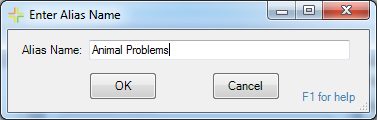
Click on the Alias Names tab. Right-click under Associated Aliases and select Add . The following pop-up appears:
Enter the alias name for the Citizen Reporter layer within the service and click OK . Click onto another layer's node on the lefthand pane to save.
In ArcCatalog open the Geodatabase Configuration tool. Click on the Citizen Reporter layer's node in the left pane. Start populating field mappings in the Field Mapping Grid . You will have to manually enter the field names, as they will not show up in the field lookup list. Here are which Work Request fields you should map each of the GIS service layer’s fields to.:
Lucity Field Name
Lucity Display Name
Feature Class Field Name
Import Field
Export Field
Notes
RQ_CREW_CD
Assigned Crew
assignedto
x
RQ_EMAIL
Email
email
x
RQ_EXTERNALID
External Request ID
globalid
x
x
Common ID
RQ_LOC_STR
Loc Street Name
locdesc
x
Composite Address
RQ_MEMO2
Request to Work Order
details
x
RQ_NAME1
Name
name
x
RQ_PHONE
Phone #
phone
x
RQ_PROB_CD
Problem
probtype
x
RQ_STAT_CD
Status
status
x
In ArcCatalog open the Geodatabase Configuration tool. Click on the Citizen Reporter layer's node in the left pane and then select the Edit Map Service tab in the center. Right-click on the Citizen Reporter layer’s node and select Add > Scheduled Task .
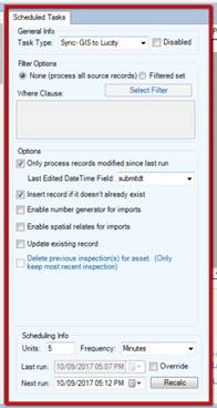
Begin configuring settings for the task. You should set them exactly like this:Task Type : Sync- GIS to Lucity.Only process records modified since last run : Check this box.Last Edited DateTime Field : Manually enter "submitdt".Insert record if it doesn’t already exist : Check this box.Last run : This must be populated. Check Override , set the date value, and click into Next run .Next run : This must be populated, click Recalc to set it Other considerations.You can specify a custom where clause if needed (although not recommended if you want every incoming request to be processed). Using the date options (only process records modified since last run, last edited datetime field) is required for this integration to work. Number generators and Spatial relates cannot be setup for this layer. Scheduling units and frequency can be set to whatever works best (ideally something frequent, at least once each day).
 How to add the Citizen Reporter Service to Lucity