GIS Views are a way to define how you want the Lucity Web Map to show up for a specific set of users.
Editing Pane
When you begin to edit GIS View Properties a editing pane opens up to the right of the screens, providing a means to modify the component's properties.
Move Pane
Switches the side of the screen to which the Edit Pane is attached.
Delete
Deletes the selected Dashboard component. If the component is a Shared Tab, the system removes Shared Tab from the user's Dashboard.
Save
Saves all changes made to the Dashboard component's settings.
Cancel
Cancels any edits and closes the menu.
GIS View Properties
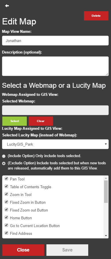
Map View Name *
The name of the GIS View. Must be unique.
Description
The name of the GIS View.
Selected Web Map *
Select a web map from your ArcGIS Portal. This is the suggested method. This requires the Portal for ArcGIS integration to be setup.
Selected Lucity Map *
Select a map from the legacy Lucity map setup.
Include Option
Controls how tools are selected in the tool grid. This option only includes tools that are selected in the grid.
Exclude Option
Contols how tools are selected in the tool grid. This option excludes options that are not selected in the grid. This means that as new tools are added to the webmap they are automatically checked and therefor included in the GIS View.
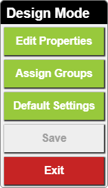
In the web map click the button. The design Mode pop-up appears:
Select Edit Properties from the pop-up.
The edit pane will appear.
Make sure there is a Map View Name. This is required and must be unique.
Enter a Description if desired.
Select a Web Map to display.
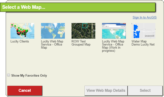
If you have configured your Portal for ArcGIS Integration click the Select button under the Selected Web Map field.. The following pop-up will appear:
The maps in the pop-up come from your ArcGIS portal.
Note: You are only selecting the initial map that will be displayed. After loading the webmap users will be able to select any Portal map that they have access to.
Click Select.
OR
If you haven't configured your Portal for ArcGIS Integration you can still use the legacy Lucity Map setup. Use the Selected Webmap dropdown to choose a lucity map.
Note: You are only selecting the initial map that will be displayed. After loading the webmap users will be able to select any web map that they have access to.
Select Tools
Select the Include Method if you want to strictly control all the tools that your users get access to. As new tools are added to the webmap they will not be included automatically.
Uncheck the tools that you do not want to include in the web map.
If new tools are added that you want to include in the view you will need to edit the view and add check the boxes to include them.
OR
Select the Exclude Method if you want to remove some tools from the gis view but you want new tools to be added automatically as they are released.
Uncheck the tools that you want to exclude from the webmap.
If new tools are added that you want to exlude in the GIS view you will need to edit the view and uncheck the boxes to exclude them.
 How to fill out GIS View Properties
 button. The design Mode pop-up appears: