Field/Button Name
Special Function
Street Intersection Name Fields
These four fields are used for declaring the proper street names for each leg entering the intersection. You cannot enter more than four unique street names for a single intersection.
ADT Volume and Date
The data in these fields is used for budget forecasting in the Modeling module in the Pavement module. These fields record traffic volume data.
Note: The traffic volume can be calculated automatically using the Toolkit function.
Intersection Lock
The Intersection Lock check-box is used if your system is integrated with GIS. If this box is marked, the intersection will not be recalculated in the GIS system.
Leg Assign
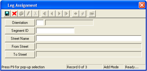
The Leg Assign button helps create a diagram of your street intersections. To draw your intersections, follow the steps below:
- Click on the Leg Assign button and the following window will appear:

- Select the orientation (N, S, E, W, etc.) from the pick list. This is the direction of an intersection leg as it travels away from the node point.
- Select the Segment ID from the pick list. This represents the street traveling out of the node point as described by its orientation. Once the Segment ID has been selected, the system will automatically fill the Street Name, From Street, and To Street fields.
- Click
 to save the record.
 - Click
 to close the window.
Note: You'll repeat this process for each of the Street Intersection Names listed on the General tab.