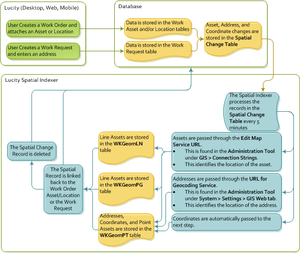
The Lucity Spatial Indexer reviews addresses, coordinates, and assets on Work Orders and Work Requests and stores the related spatial information in a special table. This data can then be viewed using special Lucity GIS tools.
Configuration
Note: All of the feature classes that are linked to Lucity should be contained in this service or in an alternate feature service that is directly linked to the feature classes in the geodatabase configuration.
Note: The Spatial Indexer relies on back-end tables that were added to the program in version 7.4 and have been populated since. Therefore, the Indexer can only process Work data added after an agency upgraded to version 7.4 or greater.
Restrictions
Process
Records That Fail To Process
Sometimes, certain records fail to process. When a Spatial Change record cannot be processed, it is kept in the Spatial Change table (GBAWork.WKSPATIALCHANGE) and tagged with an error code. Failed records are kept in the Spatial Change table for 30 days after they were processed, and then they are deleted.
Error Codes
Error codes appear in the GBAWork.WKSPATIALCHANGE.SPCH_SU_ERROR field.
MissingData |
Usually indicates that there is an issue with the record in the WKSPATIALCHANGE table; for example, the moduleID is invalid, the ParentRecID is invalid, or there is invalid x/y data, etc. |
ServiceIssue |
Denotes that:
|
NoGeometry |
Signifies that:
|
NoLucityRecord |
Indicates that the associated record no longer exists in Lucity. |
How To Process Records That Have Failed