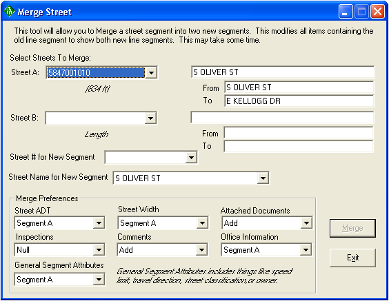
To access this tool, click the Merge Streets button. The following window will appear:

To merge two streets together, complete the following steps:
Note: The Inspections option is not currently used. At this time, the inspections remain on their existing subsegments. If there is an inspection tied to each street, and the streets are not subsegmented prior to the merge, the merge tool will subsegment the street at the merge point in order to keep the existing inspections.
Option |
Description |
Applies To |
Average |
Takes an average of the values (ADT, Width) from the two original segments. |
Street ADT, Street Width, |
Proportional Average |
Takes a proportional average of the ADT or Width based on the length of the two original segments. |
Street ADT, Street Width |
High Value |
Uses the highest ADT or Width value. |
Street ADT, Street Width |
Low Value |
Uses the lowest ADT or Width value. |
Street ADT, Street Width |
Add |
For values, adds the ADT value from each original segment to calculate the new ADT value. OR For Comments/Documents, adds all items attached to the two original segments to the newly merged segment. |
Street ADT, Attached Documents, Comments |
Null |
For values/attributes, sets the value/attributes to Null for the newly merged segment. OR For documents/comments, drops all attached information for the newly merged segment. |
Street ADT, Street Width, Attached Documents, Comments, Office Information, General Segment Attributes |
Segment A |
Uses all of the applicable information from Segment A. |
Street ADT, Street Width, Attached Documents, Comments, Office Information, General Segment Attributes |
Segment B |
Uses all of the applicable information from Segment B. |
Street ADT, Street Width, Attached Documents, Comments, Office Information, General Segment Attributes |
Note: You will be prompted when the merge is complete.