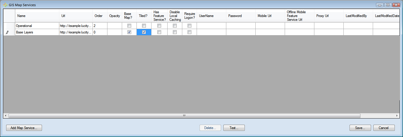
The GIS Map Services window allows administrators to connect Lucity to map services available on the web or that they have set up in Arc Server. Defining map services in this dialog defines them as an available service to add to a web or viewer map.
Note: Map services must be added to this setup screen before they can be added to the GIS Map Setup dialog.

Using the Grid
To edit an existing map service, click in a field and begin typing.
Buttons |
|
Add Map Service |
Adds a new line to enter Map service Information |
Delete |
Deletes the selected map service |
Test |
Displays a popup that shows the map service url, and a list of layers that it recognizes as connected to Lucity. |
Save |
Saves Edits made in the Grid |
Cancel |
Closes the window without saving. |
Fields |
|
Name |
A unique name for the map service. This is used to identify the map service during setup. |
URL |
The URL of the map service, or Path of a local map package. A map service URL will usually look something like this http://<server name>/ArcGIS/rest/services/<service name>/MapServer. This must include /rest after ArcGIS. Note: In Arc 10.x the <service name> is case sensitive. For information about including Bing services go here. |
Order |
The order in which map services will appear when used together. Lower numbers will appear underneath higher numbers. Basemap services will always be on the bottom. |
Opacity |
Controls the opacity of this service. |
Base Map? |
Mark whether a layer should be used as a base map. All layers marked as a Base map will be available to all users in the base map selection tool in the webmap. This functionality is not available in the Lucity GIS Viewer or Lucity Mobile app. Note: Basemaps must be either a Tiled Map service, Image service, or Bing Map. Note: Basemaps can have a different spatial reference than other layers. However, when the basemap is loaded in the webmap it will cause the map to zoom to full extent and lose the users current location. |
Tiled? |
Mark whether the service is tiled. Tiling allows multiple concurrent requests and cached tiles perform faster. |
Has Feature Service? |
Indicates if the map service has an associated feature service. If a feature service is available editing will be enabled for this service's layers in the |
Disable Local Caching |
Prevents the mapping tools from using locally cached data. They will always request the latest data from the server. |
Require Logon |
If the service is a secured service it should have a username and password assigned. Mark this field to force users to enter their own login credentials as an added layer of security. Note: This is currently only used for Lucity Mobile. |
User Name |
If the map service is secured enter a user name that has permission to access it. This is required for secure services that contain Lucity Operational Data. Note: If no user name/password is provided users will be required to login. Note: this is currently only used for Lucity Mobile. Lucity Web users enter credentials every time they use a webmap with a secured service. |
Password |
Enter the password for the User Name. |
Mobile URL |
If this service will be used by Lucity Mobile use this field to enter an alternative URL for the service that is available externally. |
Offline Mobile Feature Service URL |
If this service is part of a map that users might pull down to the Lucity Mobile app in Offline mode this field allows you to enter a url for an alternative map service. Map services that are taken offline have several ESRI imposed restrictions. This setting allows you to use an unrestricted map service in your webmap/mobile map but then when users take the map offline it would automatically switch to the alternative service that you designed in-line with ESRI's offline restrictions. |
Proxy URL |
Clients using a proxy can provide the proxy url here. |
Last Modified By |
The last user to modify the connection string. |
Last Modified Date |
The last date the connection string was modified. |
Last Modified Time |
The last time the connection string was modified. |
Note: More than one tiled service can be used in the map ONLY if they have the same spatial reference. If a tiled service is setup as the basemap, and another one with a different spatial reference is used as a normal map layer, the webmap will fail to render.