GIS Tasks, also called Scheduled Tasks, are designed to push data back and forth between the feature class layer and the Lucity database. There are two types of tasks:
Lucity to GIS- Currently only available for Inspection feature classes.
GIS to Lucity- Supported for all GIS-enabled modules (Inventory and Inspection).
For example, a task can push Inventory data from the feature class layer to Lucity or push Inspection data from Lucity to the feature class layer.
GIS Tasks can be configured to run automatically. The GIS Task Runner processes Scheduled Tasks based upon the frequency rate (and other criteria) established by the user.
The GIS Task function greatly expands the ability to integrate Lucity and GIS through feature services. Lucity can pick up edits to the feature service, regardless of who made them or the environment in which they were made.
For example, a Task can detect edits made in:
Collector for ArcGIS (iOS & Android)- including disconnected editing,
Record merges, splits, renumbers, and deletes must still be performed an ArcMap editing environment with the Lucity extension enabled in order for the related Lucity Inspection, Construction, and Work history to be properly updated.
Features must meet the Lucity module requirements in order for the synchronization to be successful. For example, required fields, such as the Lucity Common ID, must contain a unique value.
GIS Tasks interact with the feature class through the feature services. Before setting up a GIS Task, make sure there is a feature service defined at either the feature class or geodatabase level.
Primary Uses
GIS Tasks are especially useful in:
importing Inspection records that were created in an inspection feature class layer into Lucity;
updating Lucity with edits made to feature classes layers in the Lucity Web Map; and
updating Lucity with edits made to Lucity-linked feature class layers using editing environments that aren't integrated with Lucity.
Prerequisites
In order for the GIS Task to run properly the feature classes in the feature service must contain the all of the fields that are linked to Lucity.
Considerations
When creating a GIS Task, consider:
Which Inspections should appear in the feature class?
Click the Add New GIS Task button. A new record appears in the grid.
Select the record in the grid and complete the GIS Task Info section at the bottom.
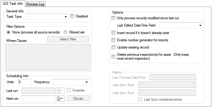
Under General Info, select the desired Task Type:
Sync - Lucity to GIS - Pushes Inspection data from Lucity to an Inspection feature class layer.
Sync - GIS to Lucity - Pushes any data from the feature class layer to Lucity.
Under Filter Options, select which records the Task will process when it runs:
None - Directs the Task to consider all records when syncing.
Filter Set - Directs the Task to consider only records that meet the criteria of a particular filter.
Select Filter - Choose an existing Lucity filter from the related module.
Under Scheduling Info, indicate how often the Task should run.
Units - Indicate the number of minutes, hours, days, or months that will pass between runs.
Frequency - Select whether the units represent minutes, hours, days, or months.
Last Run - Displays the date on which the Task was last run. (The system automatically completes this field.)
Override - Allows the user to manually modify the Last Run date.
Next Run - Displays the next date/time the Task will run. (The system automatically calculates this field based on the Last Run, Units, and Frequency fields.)
Click the Recalc button to calculate the Next Run date using the Units, Frequency and today's date.
Under Options, set how the GIS Task should behave when populating the feature class:
Only process records modified since last run - Directs the Task to check the records' Last Modified dates. Only records (in the filter set) that were modified since the Last Run date are synced.
Last Edited DateTime Field - Directs the Task to store the date/time that the record was last edited (typically the ESRI Editor Tracking field). This option is only enabled when the Only Process records modified since last run option is checked and the Task Type is Sync- GIS to Lucity.
Insert record if it doesn't already exist - Tells the Task to add any new records to the destination.
Enable number generator for imports - Directs the Task to assign numbers to assets using a Lucity GIS Number Generator related to the feature class.
Update existing record - Tells the Task to update existing records with new attribute data.
Delete previous inspection(s) for asset. (Only keep most recent inspections) - Directs the Task to delete any Inspection in the feature class that is not the most recent Inspection for an asset. The option is helpful if an agency wants the feature class to contain only the most recent Inspection for each feature. (Enabled only when the Task Type is Sync- Lucity to GIS.)
Click on a different part of the tool to save changes.
Note:History section - This section contains information about the last time the GIS Task ran.
 How to add a GIS Task