Measurements
![]()
The Measurements toolbar provides a set of tools for measuring lines and polygons on the map. When using these tools, users can control the units of measurement.

|
|
Line |
Draws a line with multiple segments. Provides a measurement for each segment as well as a total for the entire line. |
|
|
Polygon |
Draws a closed polygon defined by arrays of coordinates. Provides measurements for each line that makes up the polygon as well as the area of the whole polygon. |
|
|
Linear UoM |
Controls the unit of measurement used when measuring lines. |
|
|
Area UoM |
Controls the unit of measurement used to determine the area of a polygon. |
|
|
White Font |
Switches the color for the text displayed next to the measurement in the map to white. |
|
|
Delete Measurements |
Removes all lines and polygons added to the map by the measurement tool. |
|
|
Close |
Closes the toolbar. |
-
Select
 on the toolbar. The Measurement toolbar appears:
- Set the desired Linear UOM for the line.
- Select
 . The cursor changes to the Line tool.
 - Select a location on the map to start the measurement.
-
Select another location in the map to end a section of the line segment and begin a new one. Continue until all segments are marked.
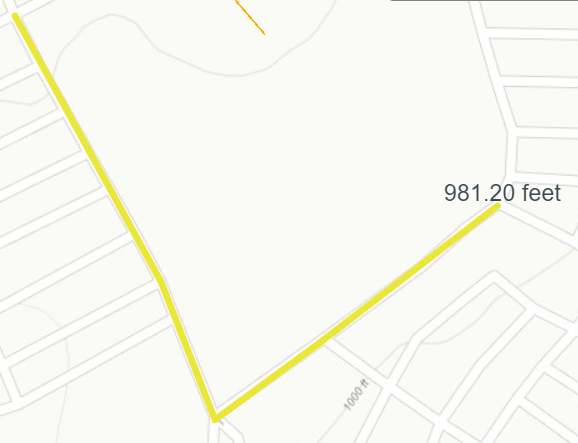
The total length of the line is displayed at the end of the line.
- Double-click to end the line. The measurement line will stay in the map.
-
Select
on the toolbar. The Measurement toolbar appears:
- Set the desired Area UOM for the polygon.
- Select
 . The cursor changes to the Polygon tool.
 - Select a location on the map to start drawing the polygon.
-
Select another location in the map to finish a side of the polygon and begin a new side.
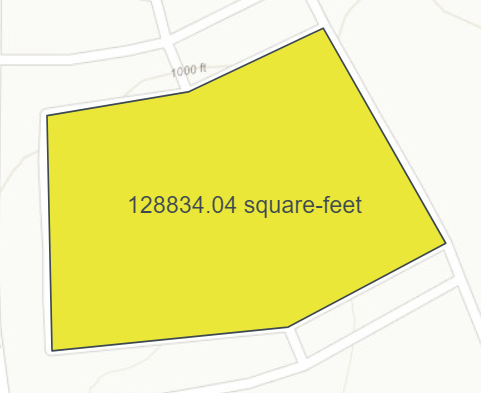
The area of the polygon (shaded part) is displayed in the center of the polygon.
- Double-click the last point to end the polygon. The polygon will stay in the map.
Note: The Measurement tool must be closed before other map drawing tools are opened.