Module Spatial Data Tool
![]()
The Module Spatial Data tool enables users to display Lucity Work data and some Inspection data in the map. These data layers represent a live, spatial view of the information in the Lucity database.
Data from the following EAM modules can be viewed in the web map using the Module Spatial Data tool. The number of geometries a given record can have is indicated in parentheses.
Sewer
-
Pipe TV Inspections
-
Sewer TV Observation (1): Distance.
-
-
Pipe CCTV Assessment
-
Sewer CCTV Observation (1): Distance.
-
-
Pipe Smoke Tests
-
Sewer Smoke Observation (1): XY if populated; then distance, if populated, then address.
-
-
Building Inspections
-
Sewer Building Observation (1): XY if populated; otherwise distance.
-
-
Overflows
-
Sewer Overflow (1): XY if populated; otherwise address.
-
Sewer Overflow Pipe (1): Asset.
-
Sewer Overflow Lateral (1): Asset.
-
Sewer Overflow Structure (1): Asset.
-
Storm
-
Storm CCTV Assessment
-
Storm CCTV Observation (1): Distance
-
-
Storm Conduit Inspections
-
Storm Conduit Observation (1): Distance
-
-
Storm Illicit Discharge
-
(1): XY if populated, then structure asset if populated, then discharge point asset if populated, then conduit asset if populated, then address
-
-
Storm Sampling
-
(1): XY if populated, otherwise structure asset
-
Street
-
Routes
-
Street Route Segment (1): Asset
-
-
Sidewalk Inspections
-
Street Curb Inspection Problem (1): XY if populated, otherwise distance
-
-
Curb Inspections
-
Street Curb Inspection Problem (1): XY if populated, otherwise distance
-
Water
-
Flushing Routes
-
Water Flushing Route Hydrant (1): Asset
-
Water Flushing Route System Valve (1): Asset
-
Water Flushing Route Pipe (1): Asset
-
-
Mainbreaks
-
Distribution (1): XY if populated, then pipe asset if populated, then address
-
-
-
Raw (1): XY if populated, then pipe asset if populated, then address
-
-
-
Recycled (1): XY if populated, then pipe asset if populated, then address
-
Work
-
Work Requests
-
(3): Asset if populated, XY if populated, and Address if populated
-
-
Work Orders
-
Work Order Location (1): XY if populated, otherwise address
-
Work Order Asset (1): Asset
-
-
Work Permits
-
(2): XY if populated and Address if populated
-
-
PM/Templates
-
Work PM/Template Location (1): XY if populated, otherwise address
-
Work PM/Template Asset (1): Asset
-
-
Master Projects
-
Work Master Project Asset (1): Asset
-
-
Projects
-
Work Project Asset (1): Asset
-
Prerequisites
To use the Module Spatial Data tool, an agency must be running the Spatial Updater.
In this section
Common Tasks
 Requires the GIS > Lucity GIS > Module Spatial Setup - Edit/Delete permission.
-
Select
 . The following dialog appears:
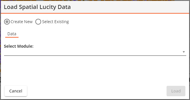
-
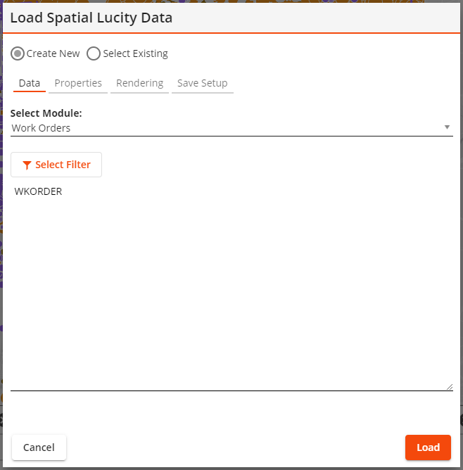
Use the Select Module drop down to select which module this layer is for. The dialog will expand:
- Filter Results:
Select Select Filter .
For more information about acquiring filters, refer to Plug-in Setup > Selecting Filters.
- Select Limit results to current map extent to only display results that would show up in the current bounds displayed in the map.
- Configure desired fields:
In the Properties tab, select any additional fields that should be included in the results.
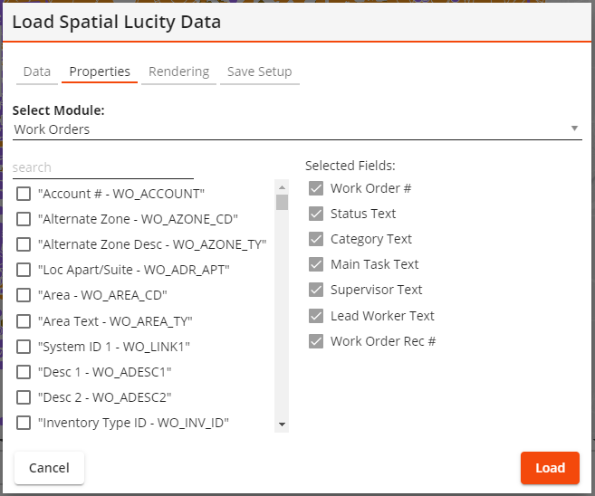
- Use Select Module to identify which part of the record the field comes from.
- Use Select Field to pick one or more fields to add to the results. Check the box next to each desired field.
- Configure layer properties in the Rendering tab:
- Enter the Layer Title that should be displayed in the Table of Contents.
- For simple rendering/symbology select a Symbol Color.
- For more complex rendering/symbology mark the Color code based on field box.
Select a Field on which to base the rendering/symbology.
Click on the Color Palette to select a different set of colors.
Click Assign Colors to assign specific colors to specific field values.
- If desired, change the number in the Symbol Size field.
- If desired, set the Auto Refresh Interval to make the layer automatically update with new data.
- Edit the information under Save Setup tab if desired.
- Enter a Setup Name and Setup Description.
- Select Save to store the configuration. You will be able to load the configuration later.
- Select Load. The spatial data is loaded into the map and will appear in the Table of Contents.
Requires the GIS > Lucity GIS > Module Spatial Setup - Edit/Delete or GIS > Lucity GIS > Module Spatial Setup - Edit/Delete My Own permission.
-
Select
. The following dialog appears:
-
Select Select Existing. The dialog will expand.
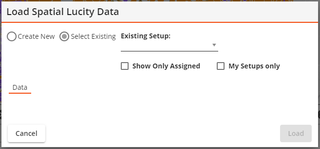
- Select an Existing Setup. If needed use the Show only setups assigned to this GIS View and Show my setups only boxes to limit the number of options.
-
A dialog will expand and will look similar to the following:
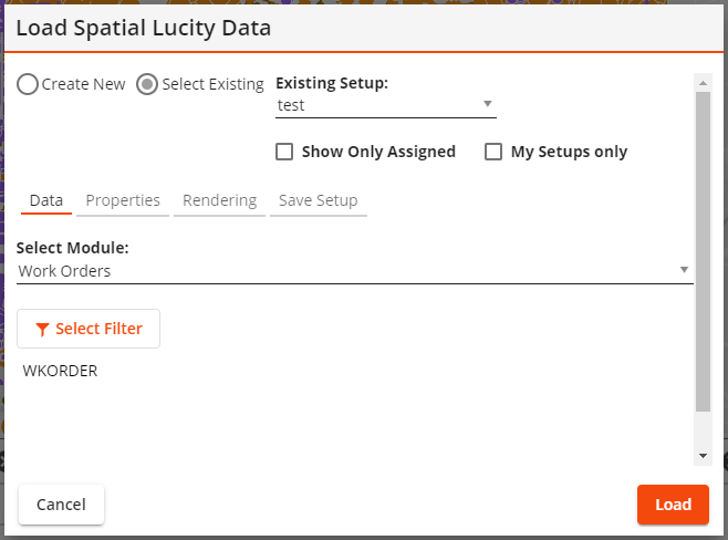
- Filter Results:
- Click Select Filter to select a filter. More information about acquiring filters.
- Select Limit results to current map extent to only display results that would show up in the current bounds displayed in the map.
- Configure desired fields:
In the Properties tab, select any additional fields that should be included in the results.
- Use Select Module to identify which part of the record the field comes from.
- Use Select Field to pick one or more fields to add to the results. Check the box next to each desired field.
- Configure layer properties in the Rendering tab:
- Enter the Layer Title that should be displayed in the Table of Contents.
- For simple rendering/symbology select a Symbol Color.
- For more complex rendering/symbology mark the Color code based on field box.
Select a Field on which to base the rendering/symbology.
Select the Color Palette to select a different set of colors.
Select Assign Colors to assign specific colors to specific field values.
- If desired change the number in the Symbol Size field.
- If desired set the Auto Refresh Interval to make the layer automatically update with new data.
- Edit the information under Save Setup tab if desired.
- Enter a Setup Name and Setup Description.
- Select Save to store the configuration. You will be able to load the configuration later.
- Select Load. The spatial data is loaded into the map and will appear in the Table of Contents.
Requires the GIS > Lucity GIS > Module Spatial Setup - Edit/Delete or GIS > Lucity GIS > Module Spatial Setup - Edit/Delete My Own permission.
- Select .
-
Click on Select Existing. The dialog will open:
- Select the Existing Setup that needs to be removed. If needed use the Show only setups assigned to this GIS View and Show my setups only boxes to limit the number of options.
-
A dialog will expand and will look similar to the following:
- Open the Save Setup tab.
- Select Delete. The dialog closes and the saved layer setup is deleted.
- Open the GIS View that needs an assigned Module Spatial Layer.
- Select .
-
Select Select Existing. The dialog will expand.
- Select an Existing Setup. If needed use the Show only setups assigned to this GIS View and Show my setups only boxes to limit the number of options.
-
A dialog will expand and will look similar to the following:
- Open the Save Setup tab.
- Select Assign to add it to the current GIS view.
- Select Cancel to close the dialog. The Module Spatial Layer will appear the next time the GIS View is loaded.